Mount Airy night lights from space
Night Light of Mount Airy (Maryland) from space (United States) Src. Average luminocity for 10x10km area is 23.4286% and for 50x50km: 25.6167%.
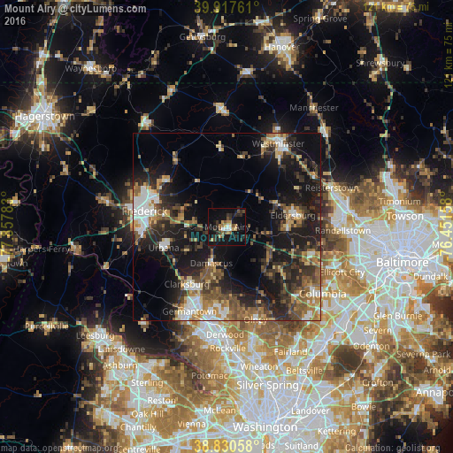
Analysis of Mount Airy night lights 2016
Square area 10x10 km:
 1.7%
1.7%90-99
1.7%80-89
2.21%70-79
4.08%60-69
3.91%50-59
2.38%40-49
3.4%30-39
5.44%20-29
7.65%10-19
32.14%0-9
35.37%Square area 50x50 km:
3.28%90-99
3.17%80-89
2.44%70-79
3.31%60-69
3.78%50-59
4.65%40-49
4.09%30-39
5.93%20-29
8.21%10-19
19.73%0-9
41.4%Clear (daylight) street map image can be seen on geolist.org.
Map coordinates:
39° 55' 3.4" North, 77° 51' 28.2" West
39° 22' 34.4" North, 77° 9' 16.9" West
38° 49' 50.1" North, 76° 27' 5.7" West
Some cities around Mount Airy sort by population:
• Eldersburg
17.8 km =11.1 mi,  80°
80°
• Damascus
10.6 km =6.6 mi,  203°
203°
• Clarksburg
18.7 km =11.6 mi,  215°
215°
• Green Valley
14.3 km =8.9 mi,  238°
238°
• Urbana
17.8 km =11.1 mi,  251°
251°
• Linganore
8.5 km =5.3 mi,  327°
327°
• Walkersville
20.9 km =13 mi,  305°
305°
• Spring Ridge
17.2 km =10.7 mi,  279°
279°
4362882 (p: 9,380)
Sources (retrieved 2019-11-25):
» Earth at Night: Flat Maps 2012, 2016