Clarksburg night lights from space
Night Light of Clarksburg (Maryland) from space (United States) Src. Average luminocity for 10x10km area is 43.8588% and for 50x50km: 36.911%.
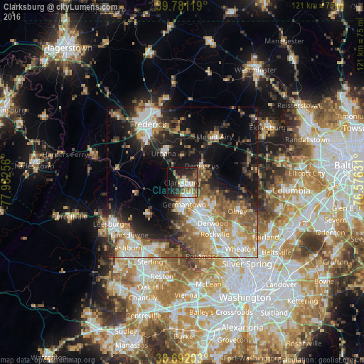
Analysis of Clarksburg night lights 2016
Square area 10x10 km:
 6.97%
6.97%90-99
6.97%80-89
8.84%70-79
3.4%60-69
4.42%50-59
5.95%40-49
7.99%30-39
9.18%20-29
13.95%10-19
23.81%0-9
8.5%Square area 50x50 km:
6.79%90-99
6.77%80-89
4.55%70-79
4.79%60-69
6.05%50-59
6.16%40-49
4.51%30-39
5.05%20-29
8.18%10-19
15.64%0-9
31.51%Clear (daylight) street map image can be seen on geolist.org.
Map coordinates:
39° 46' 52.3" North, 77° 58' 57.2" West
39° 14' 19.4" North, 77° 16' 45.9" West
38° 41' 31.3" North, 76° 34' 34.7" West
Some cities around Clarksburg sort by population:
• Germantown
7.3 km =4.5 mi,  174°
174°
• Gaithersburg
12.5 km =7.8 mi,  147°
147°
• Montgomery Village
10 km =6.2 mi,  133°
133°
• Redland
15.6 km =9.7 mi, 131°
• Damascus
8.5 km =5.3 mi,  49°
49°
• Green Valley
8 km =5 mi,  348°
348°
• Urbana
11.5 km =7.1 mi,  327°
327°
• Darnestown
15.1 km =9.4 mi,  183°
183°
4351708 (p: 13,766)
Sources (retrieved 2019-11-25):
» Earth at Night: Flat Maps 2012, 2016