Covington night lights from space
Night Light of Covington (Washington) from space (United States) Src. Average luminocity for 10x10km area is 48.6652% and for 50x50km: 37.7225%.
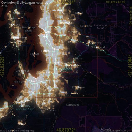
Analysis of Covington night lights 2016
Square area 10x10 km:
 5.36%
5.36%90-99
8.04%80-89
4.32%70-79
10.12%60-69
8.48%50-59
6.25%40-49
7.74%30-39
13.84%20-29
21.58%10-19
13.99%0-9
0.3%Square area 50x50 km:
10.03%90-99
8.38%80-89
3.41%70-79
4.62%60-69
6.11%50-59
5.72%40-49
4.24%30-39
3.56%20-29
5.09%10-19
7.22%0-9
41.62%Clear (daylight) street map image can be seen on geolist.org.
Map coordinates:
47° 49' 56.4" North, 122° 49' 31" West
47° 21' 29.4" North, 122° 7' 19.8" West
46° 52' 47" North, 121° 25' 8.5" West
Some cities around Covington sort by population:
• Kent
8.9 km =5.5 mi,  286°
286°
• Auburn
9.8 km =6.1 mi,  234°
234°
• East Hill-Meridian
7 km =4.3 mi,  326°
326°
• Maple Valley
6.9 km =4.3 mi,  56°
56°
• Fairwood
10.4 km =6.5 mi,  345°
345°
• Lea Hill
5.7 km =3.5 mi, 231°
• Lakeland North
12 km =7.5 mi,  256°
256°
• Lake Morton-Berrydale
3.2 km =2 mi,  153°
153°
5791159 (p: 19,197)
Sources (retrieved 2019-11-25):
» Earth at Night: Flat Maps 2012, 2016