Lea Hill night lights from space
Night Light of Lea Hill (Washington) from space (United States) Src. Average luminocity for 10x10km area is 63.1488% and for 50x50km: 39.1092%.
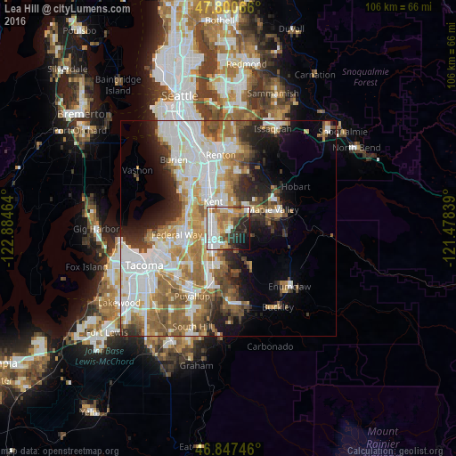
Analysis of Lea Hill night lights 2016
Square area 10x10 km:
 16.96%
90-99
15.33%80-89
5.06%70-79
11.9%60-69
9.67%50-59
5.21%40-49
4.32%30-39
7.44%20-29
12.35%10-19
9.67%0-9
2.08%Square area 50x50 km:
10.79%90-99
8.8%80-89
3.5%70-79
4.61%60-69
6.03%50-59
6.15%40-49
4.08%30-39
3.58%20-29
5.34%10-19
7.52%0-9
39.6%Clear (daylight) street map image can be seen on geolist.org.
Map coordinates:
47° 48' 2.4" North, 122° 53' 4.7" West
47° 19' 34.4" North, 122° 10' 53.4" West
46° 50' 50.9" North, 121° 28' 42.2" West
Some cities around Lea Hill sort by population:
• Kent
7.3 km =4.5 mi,  326°
326°
• Auburn
4.1 km =2.5 mi,  239°
239°
• East Hill-Meridian
9.4 km =5.8 mi,  3°
3°
• Covington
5.7 km =3.5 mi,  51°
51°
• Lakeland North
7.2 km =4.5 mi,  276°
276°
• Lakeland South
9.3 km =5.8 mi, 235°
• Lake Morton-Berrydale
6 km =3.7 mi,  83°
83°
• Pacific
8.6 km =5.3 mi,  217°
217°
5555235 (p: 13,182)
Sources (retrieved 2019-11-25):
» Earth at Night: Flat Maps 2012, 2016