Lakeland North night lights from space
Night Light of Lakeland North (Washington) from space (United States) Src. Average luminocity for 10x10km area is 82.8824% and for 50x50km: 43.6803%.
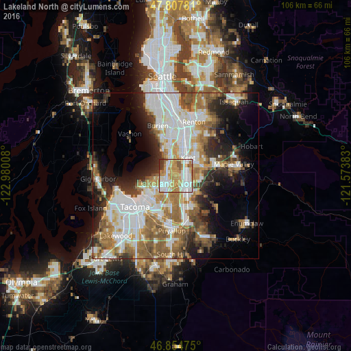
Analysis of Lakeland North night lights 2016
Square area 10x10 km:
 23.21%
90-99
24.55%80-89
8.93%70-79
22.17%60-69
11.01%50-59
4.61%40-49
1.34%30-39
3.72%20-29
0.45%10-19
0%0-9
0%Square area 50x50 km:
11.66%90-99
9.66%80-89
3.94%70-79
5.28%60-69
6.91%50-59
6.9%40-49
4.6%30-39
4.21%20-29
6.57%10-19
9.33%0-9
30.93%Clear (daylight) street map image can be seen on geolist.org.
Map coordinates:
47° 48' 28.1" North, 122° 58' 48.3" West
47° 20' 0.3" North, 122° 16' 37" West
46° 51' 17.1" North, 121° 34' 25.8" West
Some cities around Lakeland North sort by population:
• Kent
6.2 km =3.9 mi,  30°
30°
• Federal Way
3 km =1.9 mi,  245°
245°
• Auburn
4.7 km =2.9 mi,  128°
128°
• Des Moines
8.4 km =5.2 mi,  334°
334°
• Lea Hill
7.2 km =4.5 mi,  96°
96°
• Edgewood
9.4 km =5.8 mi,  187°
187°
• Milton
9.9 km =6.2 mi,  195°
195°
• Pacific
7.9 km =4.9 mi,  165°
165°
7261608 (p: 12,942)
Sources (retrieved 2019-11-25):
» Earth at Night: Flat Maps 2012, 2016