Commerce night lights from space
Night Light of Commerce (California) from space (United States) Src. Average luminocity for 10x10km area is 99.6066% and for 50x50km: 89.292%.
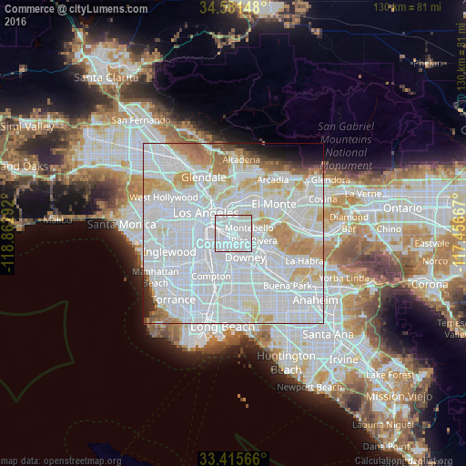
Analysis of Commerce night lights 2016
Square area 10x10 km:
 80.59%
90-99
19.23%80-89
0.17%70-79
0%60-69
0%50-59
0%40-49
0%30-39
0%20-29
0%10-19
0%0-9
0%Square area 50x50 km:
51.67%90-99
23.04%80-89
6.19%70-79
6.39%60-69
4.12%50-59
1.81%40-49
1.18%30-39
0.91%20-29
1.46%10-19
1.7%0-9
1.54%Clear (daylight) street map image can be seen on geolist.org.
Map coordinates:
34° 34' 53.3" North, 118° 51' 46.5" West
34° 0' 2.1" North, 118° 9' 35.2" West
33° 24' 56.4" North, 117° 27' 24" West
Some cities around Commerce sort by population:
• East Los Angeles
2.8 km =1.7 mi,  336°
336°
• Boyle Heights
5.6 km =3.5 mi,  311°
311°
• Pico Rivera
6.1 km =3.8 mi,  108°
108°
• Montebello
5.1 km =3.2 mi,  78°
78°
• Bell Gardens
4 km =2.5 mi,  168°
168°
• Bell
3.6 km =2.2 mi,  224°
224°
• Maywood
2.8 km =1.7 mi,  236°
236°
• Cudahy
5 km =3.1 mi,  207°
207°
5338929 (p: 13,081)
Sources (retrieved 2019-11-25):
» Earth at Night: Flat Maps 2012, 2016