Edgemoor night lights from space
Night Light of Edgemoor (Delaware) from space (United States) Src. Average luminocity for 10x10km area is 75.1599% and for 50x50km: 50.678%.
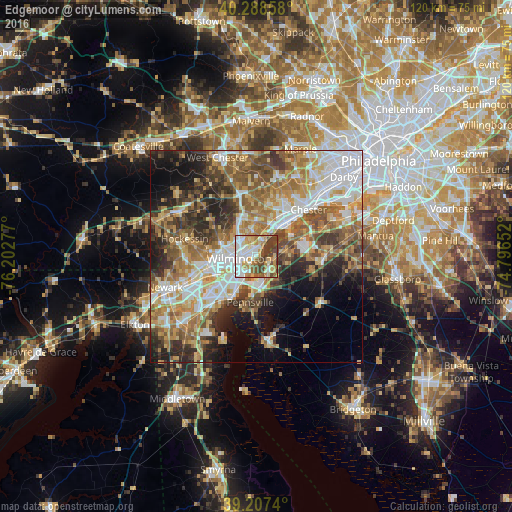
Analysis of Edgemoor night lights 2016
Square area 10x10 km:
 18.71%
90-99
19.56%80-89
11.05%70-79
11.56%60-69
9.35%50-59
7.99%40-49
13.95%30-39
7.82%20-29
0%10-19
0%0-9
0%Square area 50x50 km:
10.31%90-99
9.47%80-89
6.68%70-79
8.04%60-69
9.09%50-59
8.22%40-49
6.98%30-39
7.3%20-29
7.84%10-19
8.45%0-9
17.62%Clear (daylight) street map image can be seen on geolist.org.
Map coordinates:
40° 17' 18.9" North, 76° 12' 10" West
39° 45' 0.4" North, 75° 29' 58.7" West
39° 12' 26.6" North, 74° 47' 47.5" West
Some cities around Edgemoor sort by population:
• Wilmington
4 km =2.5 mi,  263°
263°
• Pennsville
10.8 km =6.7 mi,  187°
187°
• Claymont
6.6 km =4.1 mi,  31°
31°
• Wilmington Manor
10.1 km =6.3 mi,  225°
225°
• Village Green-Green Ridge
14.1 km =8.8 mi, 26°
• Carneys Point
5 km =3.1 mi,  149°
149°
• Elsmere
8.5 km =5.3 mi, 261°
• New Castle
11.3 km =7 mi,  210°
210°
4142398 (p: 5,677)
Sources (retrieved 2019-11-25):
» Earth at Night: Flat Maps 2012, 2016