South Kensington night lights from space
Night Light of South Kensington (Maryland) from space (United States) Src. Average luminocity for 10x10km area is 93.5779% and for 50x50km: 75.0177%.
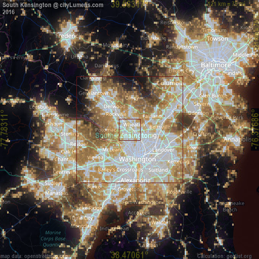
Analysis of South Kensington night lights 2016
Square area 10x10 km:
 31.98%
90-99
37.01%80-89
23.7%70-79
6.66%60-69
0.65%50-59
0%40-49
0%30-39
0%20-29
0%10-19
0%0-9
0%Square area 50x50 km:
24.22%90-99
18.16%80-89
9.72%70-79
12.27%60-69
11.09%50-59
8.11%40-49
4.07%30-39
2.91%20-29
3.33%10-19
3.58%0-9
2.53%Clear (daylight) street map image can be seen on geolist.org.
Map coordinates:
39° 33' 47.4" North, 77° 46' 59.2" West
39° 1' 8.4" North, 77° 4' 47.9" West
38° 28' 14.2" North, 76° 22' 36.7" West
Some cities around South Kensington sort by population:
• Silver Spring
5.6 km =3.5 mi,  124°
124°
• Bethesda
4.6 km =2.9 mi,  202°
202°
• Wheaton
3.2 km =2 mi,  42°
42°
• North Bethesda
4.4 km =2.7 mi,  310°
310°
• Glenmont
5.1 km =3.2 mi,  31°
31°
• Chevy Chase
1.9 km =1.2 mi,  156°
156°
• North Kensington
1.4 km =0.9 mi, 27°
• Forest Glen
2.2 km =1.4 mi,  102°
102°
4369976 (p: 8,462)
Sources (retrieved 2019-11-25):
» Earth at Night: Flat Maps 2012, 2016