Adams Morgan night lights from space
Night Light of Adams Morgan (Washington, D.C.) from space (United States) Src. Average luminocity for 10x10km area is 99.0272% and for 50x50km: 78.6221%.
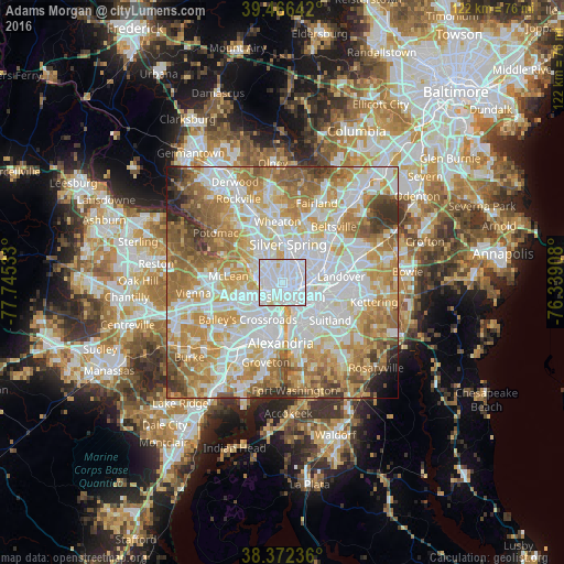
Analysis of Adams Morgan night lights 2016
Square area 10x10 km:
 72.96%
90-99
24.15%80-89
2.55%70-79
0.34%60-69
0%50-59
0%40-49
0%30-39
0%20-29
0%10-19
0%0-9
0%Square area 50x50 km:
24.39%90-99
18.65%80-89
11.69%70-79
14%60-69
11.59%50-59
8.6%40-49
4.14%30-39
3.37%20-29
2.11%10-19
0.94%0-9
0.51%Clear (daylight) street map image can be seen on geolist.org.
Map coordinates:
39° 27' 59.1" North, 77° 44' 43.2" West
38° 55' 17.4" North, 77° 2' 31.9" West
38° 22' 20.5" North, 76° 20' 20.7" West
Some cities around Adams Morgan sort by population:
• Washington, D.C.
3 km =1.9 mi,  170°
170°
• Arlington
7 km =4.3 mi,  230°
230°
• Chillum
6.5 km =4 mi,  43°
43°
• Takoma Park
7 km =4.3 mi,  25°
25°
• Shaw
2.1 km =1.3 mi,  120°
120°
• Rosslyn
3.8 km =2.4 mi,  223°
223°
• Chevy Chase
5.2 km =3.2 mi,  334°
334°
• Mount Rainier
7 km =4.3 mi,  71°
71°
4137457 (p: 15,830)
Sources (retrieved 2019-11-25):
» Earth at Night: Flat Maps 2012, 2016