Centereach night lights from space
Night Light of Centereach (New York) from space (United States) Src. Average luminocity for 10x10km area is 80.4728% and for 50x50km: 37.4954%.

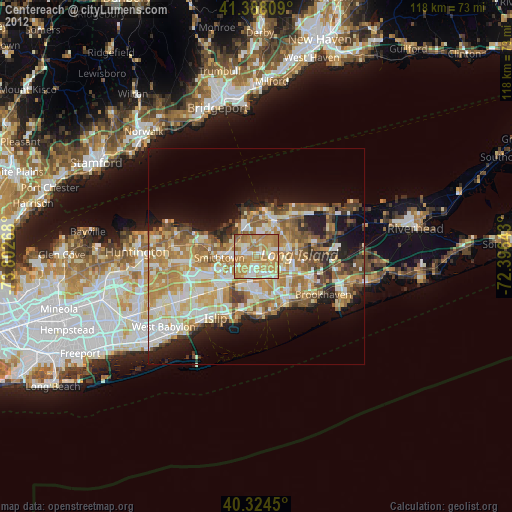
Analysis of Centereach night lights 2016
Square area 10x10 km:
 12.07%
90-99
17.18%80-89
11.39%70-79
38.61%60-69
19.39%50-59
1.36%40-49
0%30-39
0%20-29
0%10-19
0%0-9
0%Square area 50x50 km:
5.59%90-99
6.97%80-89
5.67%70-79
8.04%60-69
7.51%50-59
6.14%40-49
4.15%30-39
2.99%20-29
5.87%10-19
9.65%0-9
37.42%Clear (daylight) street map image can be seen on geolist.org.
Map coordinates:
41° 23' 17.1" North, 73° 48' 9.6" West
40° 51' 30.3" North, 73° 5' 58.4" West
40° 19' 28.2" North, 72° 23' 47.1" West
Some cities around Centereach sort by population:
• Holbrook
5.4 km =3.4 mi,  160°
160°
• Lake Ronkonkoma
3.7 km =2.3 mi,  225°
225°
• Selden
5.4 km =3.4 mi,  80°
80°
• Ronkonkoma
4.9 km =3 mi,  192°
192°
• Nesconset
4.6 km =2.9 mi,  261°
261°
• Saint James
5.3 km =3.3 mi,  295°
295°
• Terryville
6.3 km =3.9 mi,  27°
27°
• Lake Grove
1.4 km =0.9 mi,  244°
244°
5112035 (p: 31,578)
Sources (retrieved 2019-11-25):
» Earth at Night: Flat Maps 2012, 2016