Terryville night lights from space
Night Light of Terryville (New York) from space (United States) Src. Average luminocity for 10x10km area is 74.9167% and for 50x50km: 35.1184%.
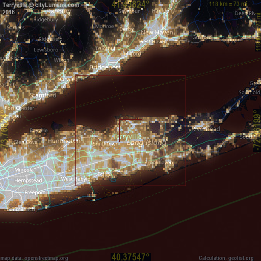
Analysis of Terryville night lights 2016
Square area 10x10 km:
 10.2%
10.2%90-99
16.5%80-89
7.82%70-79
21.94%60-69
24.66%50-59
14.63%40-49
3.91%30-39
0.34%20-29
0%10-19
0%0-9
0%Square area 50x50 km:
4.93%90-99
6.32%80-89
5.4%70-79
7.35%60-69
6.96%50-59
6.12%40-49
4.33%30-39
2.76%20-29
5.23%10-19
10.44%0-9
40.14%Clear (daylight) street map image can be seen on geolist.org.
Map coordinates:
41° 26' 17.7" North, 73° 46' 5.7" West
40° 54' 32.4" North, 73° 3' 54.4" West
40° 22' 31.7" North, 72° 21' 43.2" West
Some cities around Terryville sort by population:
• Centereach
6.3 km =3.9 mi,  207°
207°
• Selden
5.3 km =3.3 mi,  152°
152°
• East Setauket
5 km =3.1 mi,  316°
316°
• Setauket-East Setauket
3.9 km =2.4 mi,  307°
307°
• Stony Brook
6.6 km =4.1 mi,  286°
286°
• Mount Sinai
5.2 km =3.2 mi,  35°
35°
• Port Jefferson
4.2 km =2.6 mi,  355°
355°
• Port Jefferson Station
2.4 km =1.5 mi, 39°
5140694 (p: 11,849)
Sources (retrieved 2019-11-25):
» Earth at Night: Flat Maps 2012, 2016