Lake Grove night lights from space
Night Light of Lake Grove (New York) from space (United States) Src. Average luminocity for 10x10km area is 81.2483% and for 50x50km: 38.2651%.
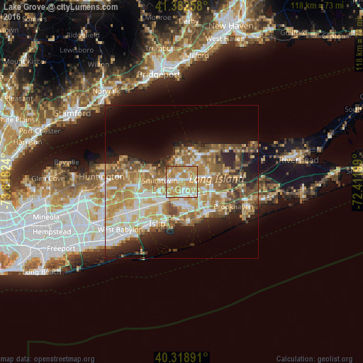
Analysis of Lake Grove night lights 2016
Square area 10x10 km:
 13.27%
90-99
18.03%80-89
12.76%70-79
37.59%60-69
16.84%50-59
1.02%40-49
0.51%30-39
0%20-29
0%10-19
0%0-9
0%Square area 50x50 km:
5.88%90-99
7.24%80-89
5.8%70-79
8.3%60-69
7.53%50-59
6.11%40-49
4.01%30-39
2.95%20-29
5.95%10-19
9.44%0-9
36.79%Clear (daylight) street map image can be seen on geolist.org.
Map coordinates:
41° 22' 57.3" North, 73° 49' 5.7" West
40° 51' 10.4" North, 73° 6' 54.4" West
40° 19' 8.1" North, 72° 24' 43.2" West
Some cities around Lake Grove sort by population:
• Centereach
1.4 km =0.9 mi,  64°
64°
• Holbrook
5.5 km =3.4 mi,  145°
145°
• Smithtown
7.2 km =4.5 mi,  272°
272°
• Selden
6.9 km =4.3 mi,  77°
77°
• Holtsville
7.2 km =4.5 mi,  125°
125°
• Ronkonkoma
4.2 km =2.6 mi,  176°
176°
• Nesconset
3.3 km =2.1 mi, 268°
• Saint James
4.6 km =2.9 mi,  309°
309°
5123796 (p: 11,235)
Sources (retrieved 2019-11-25):
» Earth at Night: Flat Maps 2012, 2016