Carrizo Springs night lights from space
Night Light of Carrizo Springs (Texas) from space (United States) Src. Average luminocity for 10x10km area is 37.6349% and for 50x50km: 5.5136%.
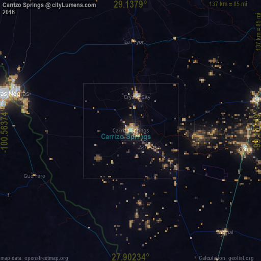
Analysis of Carrizo Springs night lights 2016
Square area 10x10 km:
 1.19%
1.19%90-99
2.38%80-89
11.31%70-79
9.72%60-69
4.76%50-59
3.97%40-49
4.56%30-39
8.73%20-29
6.55%10-19
35.52%0-9
11.31%Square area 50x50 km:
0.1%90-99
0.18%80-89
0.9%70-79
1.04%60-69
0.75%50-59
0.87%40-49
0.91%30-39
1.45%20-29
1.29%10-19
3.33%0-9
89.18%Clear (daylight) street map image can be seen on geolist.org.
Map coordinates:
29° 8' 16.4" North, 100° 33' 49.5" West
28° 31' 18.9" North, 99° 51' 38.2" West
27° 54' 8.4" North, 99° 9' 27" West
Some cities around Carrizo Springs sort by population:
• Piedras Negras, MX
67.7 km =42.1 mi,  287°
287°
• Eagle Pass
65.7 km =40.8 mi, 288°
• Nava, MX
89.2 km =55.4 mi,  262°
262°
• Uvalde
76.8 km =47.7 mi,  5°
5°
• Pearsall
85.3 km =53 mi,  61°
61°
• Eidson Road
63.5 km =39.5 mi, 285°
• Crystal City
17.6 km =10.9 mi, 10°
• Villa Union, MX
90.4 km =56.2 mi,  247°
247°
4679148 (p: 5,898)
Sources (retrieved 2019-11-25):
» Earth at Night: Flat Maps 2012, 2016