Pearsall night lights from space
Night Light of Pearsall (Texas) from space (United States) Src. Average luminocity for 10x10km area is 25.5536% and for 50x50km: 2.5785%.
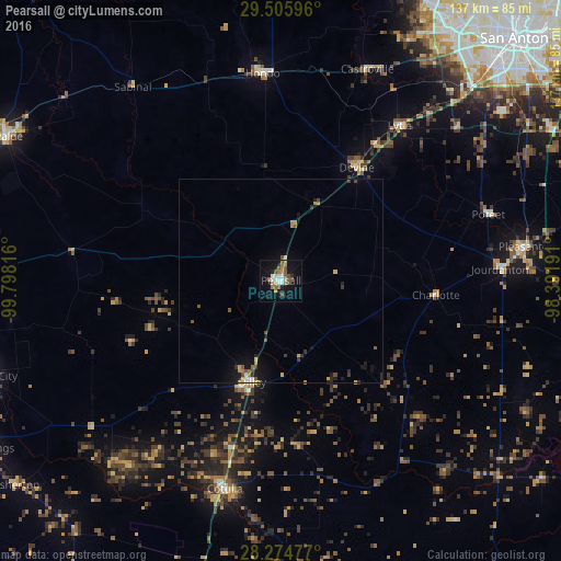
Analysis of Pearsall night lights 2016
Square area 10x10 km:
 3.77%
3.77%90-99
3.37%80-89
0.79%70-79
3.57%60-69
5.36%50-59
6.15%40-49
4.76%30-39
0%20-29
2.58%10-19
22.62%0-9
47.02%Square area 50x50 km:
0.2%90-99
0.23%80-89
0.32%70-79
0.3%60-69
0.39%50-59
0.5%40-49
0.43%30-39
0.34%20-29
0.4%10-19
2%0-9
94.89%Clear (daylight) street map image can be seen on geolist.org.
Map coordinates:
29° 30' 21.5" North, 99° 47' 53.4" West
28° 53' 31.9" North, 99° 5' 42.1" West
28° 16' 29.2" North, 98° 23' 30.9" West
Some cities around Pearsall sort by population:
• San Antonio
83.1 km =51.6 mi,  44°
44°
• Uvalde
75.9 km =47.2 mi,  297°
297°
• Leon Valley
81.5 km =50.6 mi,  34°
34°
• Lackland Air Force Base
71.9 km =44.7 mi, 40°
• Pleasanton
60.6 km =37.7 mi,  82°
82°
• Hondo
50.8 km =31.6 mi,  354°
354°
• Crystal City
75.3 km =46.8 mi,  251°
251°
• Lakehills
80.6 km =50.1 mi,  10°
10°
4718107 (p: 9,980)
Sources (retrieved 2019-11-25):
» Earth at Night: Flat Maps 2012, 2016