Forestville night lights from space
Night Light of Forestville (Maryland) from space (United States) Src. Average luminocity for 10x10km area is 90.398% and for 50x50km: 62.4512%.
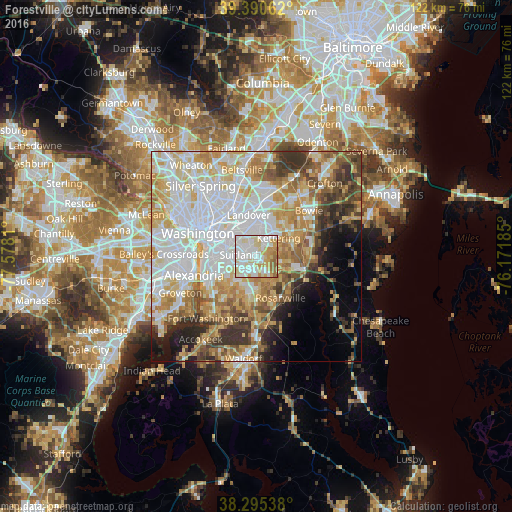
Analysis of Forestville night lights 2016
Square area 10x10 km:
 33.33%
90-99
29.93%80-89
16.84%70-79
10.71%60-69
7.31%50-59
1.87%40-49
0%30-39
0%20-29
0%10-19
0%0-9
0%Square area 50x50 km:
19.72%90-99
13.62%80-89
9.49%70-79
9.39%60-69
7.08%50-59
6.25%40-49
4.99%30-39
5.8%20-29
4.72%10-19
5.14%0-9
13.8%Clear (daylight) street map image can be seen on geolist.org.
Map coordinates:
39° 23' 26.2" North, 77° 34' 41.2" West
38° 50' 42.4" North, 76° 52' 29.9" West
38° 17' 43.4" North, 76° 10' 18.7" West
Some cities around Forestville sort by population:
• Suitland-Silver Hill
4.4 km =2.7 mi,  272°
272°
• Suitland
4.3 km =2.7 mi,  275°
275°
• Camp Springs
5.3 km =3.3 mi,  210°
210°
• Walker Mill
3.6 km =2.2 mi,  341°
341°
• Coral Hills
4.9 km =3 mi,  305°
305°
• Westphalia
5.5 km =3.4 mi,  89°
89°
• District Heights
1.9 km =1.2 mi,  318°
318°
• Silver Hill
6.1 km =3.8 mi, 266°
4355274 (p: 12,353)
Sources (retrieved 2019-11-25):
» Earth at Night: Flat Maps 2012, 2016