Morrisville night lights from space
Night Light of Morrisville (Pennsylvania) from space (United States) Src. Average luminocity for 10x10km area is 84.8052% and for 50x50km: 52.6624%.
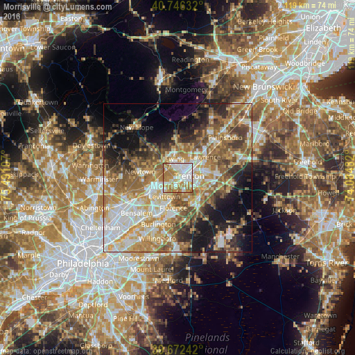
Analysis of Morrisville night lights 2016
Square area 10x10 km:
 27.27%
90-99
22.73%80-89
6.66%70-79
19.48%60-69
20.94%50-59
2.92%40-49
0%30-39
0%20-29
0%10-19
0%0-9
0%Square area 50x50 km:
9.57%90-99
9.75%80-89
8.12%70-79
9.51%60-69
9.96%50-59
8.76%40-49
6.23%30-39
5.76%20-29
6.85%10-19
11.31%0-9
14.18%Clear (daylight) street map image can be seen on geolist.org.
Map coordinates:
40° 44' 46.8" North, 75° 29' 27.9" West
40° 12' 41.4" North, 74° 47' 16.6" West
39° 40' 20.7" North, 74° 5' 5.4" West
Some cities around Morrisville sort by population:
• Trenton
3.9 km =2.4 mi,  80°
80°
• Levittown
7.2 km =4.5 mi,  208°
208°
• Ewing
6.6 km =4.1 mi,  351°
351°
• Mercerville-Hamilton Square
10.1 km =6.3 mi, 77°
• Mercerville
9.1 km =5.7 mi,  71°
71°
• White Horse
7.6 km =4.7 mi,  107°
107°
• Fairless Hills
6.7 km =4.2 mi,  238°
238°
• Prospect Park
3.7 km =2.3 mi,  29°
29°
5201996 (p: 8,605)
Sources (retrieved 2019-11-25):
» Earth at Night: Flat Maps 2012, 2016