Croydon night lights from space
Night Light of Croydon (Pennsylvania) from space (United States) Src. Average luminocity for 10x10km area is 90.4838% and for 50x50km: 68.9543%.
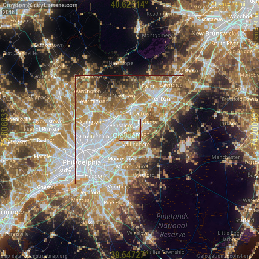
Analysis of Croydon night lights 2016
Square area 10x10 km:
 25.81%
90-99
33.44%80-89
20.94%70-79
16.72%60-69
3.08%50-59
0%40-49
0%30-39
0%20-29
0%10-19
0%0-9
0%Square area 50x50 km:
19.77%90-99
14.79%80-89
10.15%70-79
11.62%60-69
11.55%50-59
8.04%40-49
5.21%30-39
3.55%20-29
4.19%10-19
7.86%0-9
3.28%Clear (daylight) street map image can be seen on geolist.org.
Map coordinates:
40° 37' 23.3" North, 75° 36' 23.9" West
40° 5' 14.4" North, 74° 54' 12.6" West
39° 32' 50.2" North, 74° 12' 1.4" West
Some cities around Croydon sort by population:
• Levittown
9.9 km =6.2 mi,  40°
40°
• Willingboro
7.2 km =4.5 mi,  156°
156°
• Cinnaminson
12.6 km =7.8 mi,  217°
217°
• Burlington
3.7 km =2.3 mi,  118°
118°
• Bristol
4.6 km =2.9 mi,  71°
71°
• Fairless Hills
11 km =6.8 mi,  21°
21°
• Edgewater Park
2.1 km =1.3 mi,  173°
173°
• Tacony
13.5 km =8.4 mi,  242°
242°
5186053 (p: 9,950)
Sources (retrieved 2019-11-25):
» Earth at Night: Flat Maps 2012, 2016