Fairless Hills night lights from space
Night Light of Fairless Hills (Pennsylvania) from space (United States) Src. Average luminocity for 10x10km area is 82.2062% and for 50x50km: 59.9555%.
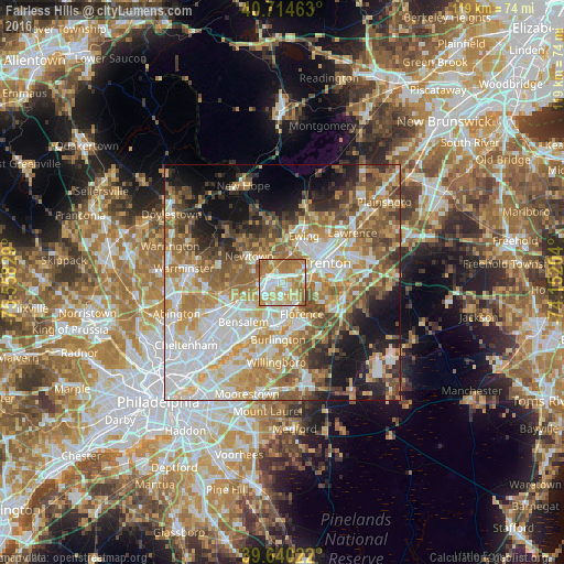
Analysis of Fairless Hills night lights 2016
Square area 10x10 km:
 17.37%
90-99
19.64%80-89
16.4%70-79
20.94%60-69
23.38%50-59
2.27%40-49
0%30-39
0%20-29
0%10-19
0%0-9
0%Square area 50x50 km:
13.37%90-99
11.89%80-89
8.96%70-79
10.47%60-69
10.73%50-59
9.11%40-49
6.18%30-39
5.24%20-29
6.05%10-19
10.43%0-9
7.58%Clear (daylight) street map image can be seen on geolist.org.
Map coordinates:
40° 42' 52.7" North, 75° 33' 29.8" West
40° 10' 46.4" North, 74° 51' 18.6" West
39° 38' 24.8" North, 74° 9' 7.3" West
Some cities around Fairless Hills sort by population:
• Trenton
10.4 km =6.5 mi,  66°
66°
• Levittown
3.5 km =2.2 mi,  140°
140°
• Ewing
11.1 km =6.9 mi,  25°
25°
• Croydon
11 km =6.8 mi,  201°
201°
• Burlington
12.1 km =7.5 mi,  183°
183°
• Bristol
8.8 km =5.5 mi, 178°
• Morrisville
6.7 km =4.2 mi,  58°
58°
• Prospect Park
10.1 km =6.3 mi,  48°
48°
5189091 (p: 8,466)
Sources (retrieved 2019-11-25):
» Earth at Night: Flat Maps 2012, 2016