Bluffton night lights from space
Night Light of Bluffton (Indiana) from space (United States) Src. Average luminocity for 10x10km area is 23.013% and for 50x50km: 4.4723%.
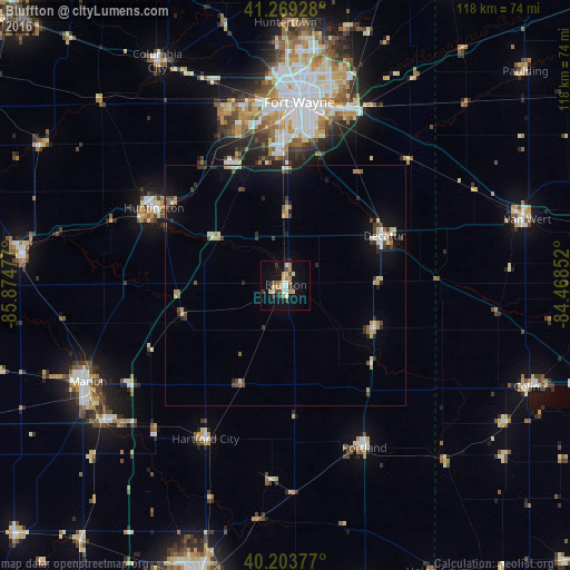
Analysis of Bluffton night lights 2016
Square area 10x10 km:
 2.44%
2.44%90-99
4.06%80-89
3.25%70-79
4.38%60-69
1.46%50-59
2.11%40-49
3.08%30-39
3.73%20-29
1.14%10-19
21.1%0-9
53.25%Square area 50x50 km:
0.35%90-99
0.57%80-89
0.64%70-79
0.5%60-69
0.44%50-59
0.46%40-49
0.75%30-39
0.76%20-29
0.7%10-19
3.09%0-9
91.75%Clear (daylight) street map image can be seen on geolist.org.
Map coordinates:
41° 16' 9.4" North, 85° 52' 29.2" West
40° 44' 19.2" North, 85° 10' 17.9" West
40° 12' 13.6" North, 84° 28' 6.7" West
Some cities around Bluffton sort by population:
• Fort Wayne
43.7 km =27.2 mi,  4°
4°
• Marion
45.8 km =28.5 mi,  244°
244°
• Huntington
31.8 km =19.8 mi,  300°
300°
• New Haven
39.2 km =24.4 mi,  19°
19°
• Decatur
22.8 km =14.2 mi,  63°
63°
• Portland
37.6 km =23.4 mi,  154°
154°
• Hartford City
36.1 km =22.4 mi,  207°
207°
• Gas City
46.6 km =29 mi,  233°
233°
4918234 (p: 10,005)
Sources (retrieved 2019-11-25):
» Earth at Night: Flat Maps 2012, 2016