Decatur night lights from space
Night Light of Decatur (Indiana) from space (United States) Src. Average luminocity for 10x10km area is 23.7262% and for 50x50km: 7.4704%.
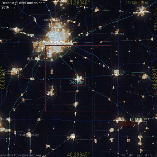
Analysis of Decatur night lights 2016
Square area 10x10 km:
 3.91%
3.91%90-99
4.42%80-89
3.91%70-79
0.85%60-69
1.87%50-59
1.19%40-49
4.08%30-39
5.27%20-29
1.87%10-19
22.79%0-9
49.83%Square area 50x50 km:
1.22%90-99
1.27%80-89
0.93%70-79
0.93%60-69
0.87%50-59
0.95%40-49
0.88%30-39
1.08%20-29
1.64%10-19
3.71%0-9
86.51%Clear (daylight) street map image can be seen on geolist.org.
Map coordinates:
41° 21' 37.7" North, 85° 37' 56.1" West
40° 49' 50.2" North, 84° 55' 44.9" West
40° 17' 47.2" North, 84° 13' 33.6" West
Some cities around Decatur sort by population:
• Fort Wayne
37.3 km =23.2 mi,  333°
333°
• Huntington
48.2 km =30 mi,  276°
276°
• New Haven
27.6 km =17.1 mi,  344°
344°
• Van Wert
29.3 km =18.2 mi,  81°
81°
• Celina
43.5 km =27 mi,  135°
135°
• Bluffton
22.8 km =14.2 mi,  243°
243°
• Portland
44.2 km =27.5 mi,  185°
185°
• Huntertown
48.7 km =30.3 mi, 335°
4919564 (p: 9,465)
Sources (retrieved 2019-11-25):
» Earth at Night: Flat Maps 2012, 2016