Bithlo night lights from space
Night Light of Bithlo (Florida) from space (United States) Src. Average luminocity for 10x10km area is 42.2841% and for 50x50km: 36.0127%.
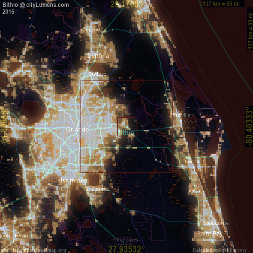
Analysis of Bithlo night lights 2016
Square area 10x10 km:
 2.65%
2.65%90-99
5.87%80-89
1.7%70-79
3.22%60-69
20.08%50-59
8.9%40-49
10.23%30-39
5.11%20-29
11.17%10-19
18.18%0-9
12.88%Square area 50x50 km:
9.17%90-99
9.24%80-89
4.33%70-79
5.42%60-69
6.41%50-59
2.84%40-49
2.79%30-39
2.66%20-29
3.35%10-19
6.38%0-9
47.39%Clear (daylight) street map image can be seen on geolist.org.
Map coordinates:
29° 10' 13.8" North, 81° 48' 34.5" West
28° 33' 17" North, 81° 6' 23.2" West
27° 56' 7.2" North, 80° 24' 12" West
Some cities around Bithlo sort by population:
• Alafaya
10.3 km =6.4 mi,  275°
275°
• Oviedo
16.2 km =10.1 mi,  322°
322°
• Winter Park
23.3 km =14.5 mi, 282°
• Conway
22.6 km =14 mi,  255°
255°
• Azalea Park
19 km =11.8 mi,  265°
265°
• Goldenrod
18.8 km =11.7 mi,  289°
289°
• Union Park
17.6 km =10.9 mi, 274°
• Wedgefield
8 km =5 mi,  159°
159°
4148012 (p: 8,268)
Sources (retrieved 2019-11-25):
» Earth at Night: Flat Maps 2012, 2016