Oviedo night lights from space
Night Light of Oviedo (Florida) from space (United States) Src. Average luminocity for 10x10km area is 69.2784% and for 50x50km: 47.1769%.
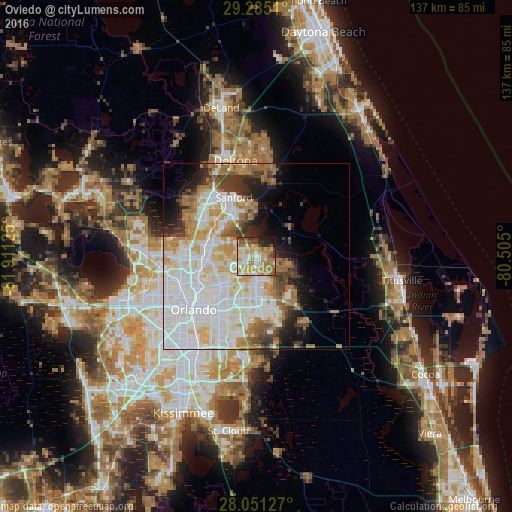

Analysis of Oviedo night lights 2016
Square area 10x10 km:
 9.47%
9.47%90-99
15.53%80-89
8.52%70-79
22.92%60-69
17.42%50-59
5.11%40-49
5.68%30-39
4.73%20-29
6.44%10-19
4.17%0-9
0%Square area 50x50 km:
14.93%90-99
13.58%80-89
4.75%70-79
5.52%60-69
6.61%50-59
3.16%40-49
2.96%30-39
3.66%20-29
4.35%10-19
6.02%0-9
34.47%Clear (daylight) street map image can be seen on geolist.org.
Map coordinates:
29° 17' 6.4" North, 81° 54' 40.5" West
28° 40' 12" North, 81° 12' 29.2" West
28° 3' 4.6" North, 80° 30' 18" West
Some cities around Oviedo sort by population:
• Alafaya
11.8 km =7.3 mi,  181°
181°
• Winter Springs
10.3 km =6.4 mi,  288°
288°
• Casselberry
11.7 km =7.3 mi,  274°
274°
• Lake Mary
14.6 km =9.1 mi,  312°
312°
• Longwood
13.2 km =8.2 mi, 286°
• Goldenrod
10.3 km =6.4 mi,  229°
229°
• Union Park
13.7 km =8.5 mi,  213°
213°
• Fern Park
14.1 km =8.8 mi,  260°
260°
4167348 (p: 38,551)
Sources (retrieved 2019-11-25):
» Earth at Night: Flat Maps 2012, 2016