Goldenrod night lights from space
Night Light of Goldenrod (Florida) from space (United States) Src. Average luminocity for 10x10km area is 93.8182% and for 50x50km: 61.8583%.
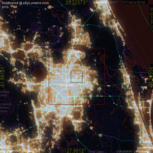
Analysis of Goldenrod night lights 2016
Square area 10x10 km:
 32.39%
90-99
39.58%80-89
18.75%70-79
9.28%60-69
0%50-59
0%40-49
0%30-39
0%20-29
0%10-19
0%0-9
0%Square area 50x50 km:
19.82%90-99
18.59%80-89
7.86%70-79
8.54%60-69
7.36%50-59
2.73%40-49
2.88%30-39
3.2%20-29
4.17%10-19
6.2%0-9
18.65%Clear (daylight) street map image can be seen on geolist.org.
Map coordinates:
29° 13' 32.6" North, 81° 59' 30.5" West
28° 36' 37" North, 81° 17' 19.2" West
27° 59' 28.3" North, 80° 35' 8" West
Some cities around Goldenrod sort by population:
• Alafaya
9.1 km =5.7 mi,  124°
124°
• Altamonte Springs
9.4 km =5.8 mi,  306°
306°
• Winter Park
5.1 km =3.2 mi,  256°
256°
• Casselberry
8.4 km =5.2 mi,  333°
333°
• Maitland
7.5 km =4.7 mi,  284°
284°
• Azalea Park
7.8 km =4.8 mi,  188°
188°
• Union Park
4.7 km =2.9 mi,  177°
177°
• Fern Park
7.5 km =4.7 mi, 305°
4156959 (p: 12,039)
Sources (retrieved 2019-11-25):
» Earth at Night: Flat Maps 2012, 2016