Union Park night lights from space
Night Light of Union Park (Florida) from space (United States) Src. Average luminocity for 10x10km area is 96.6894% and for 50x50km: 63.4654%.
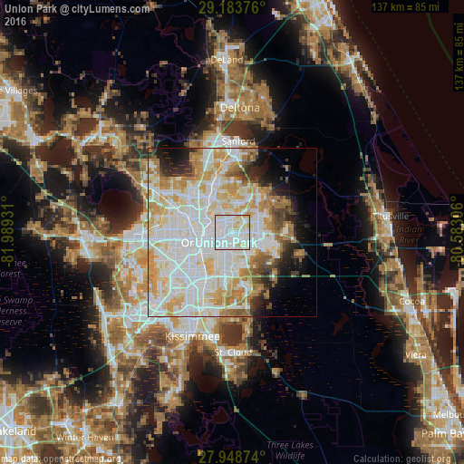
Analysis of Union Park night lights 2016
Square area 10x10 km:
 49.05%
90-99
36.55%80-89
12.5%70-79
1.89%60-69
0%50-59
0%40-49
0%30-39
0%20-29
0%10-19
0%0-9
0%Square area 50x50 km:
20.68%90-99
19.47%80-89
8.15%70-79
8.79%60-69
7.26%50-59
2.67%40-49
2.73%30-39
2.74%20-29
3.81%10-19
5.55%0-9
18.14%Clear (daylight) street map image can be seen on geolist.org.
Map coordinates:
29° 11' 1.5" North, 81° 59' 21.5" West
28° 34' 5" North, 81° 17' 10.2" West
27° 56' 55.5" North, 80° 34' 59" West
Some cities around Union Park sort by population:
• Orlando
9.7 km =6 mi,  250°
250°
• Alafaya
7.3 km =4.5 mi,  93°
93°
• Winter Park
6.3 km =3.9 mi,  304°
304°
• Maitland
10 km =6.2 mi,  311°
311°
• Conway
8.5 km =5.3 mi,  210°
210°
• Azalea Park
3.3 km =2.1 mi, 205°
• Goldenrod
4.7 km =2.9 mi,  357°
357°
• Fairview Shores
10.9 km =6.8 mi,  283°
283°
4176109 (p: 9,765)
Sources (retrieved 2019-11-25):
» Earth at Night: Flat Maps 2012, 2016