Winter Park night lights from space
Night Light of Winter Park (Florida) from space (United States) Src. Average luminocity for 10x10km area is 96.6477% and for 50x50km: 68.4627%.
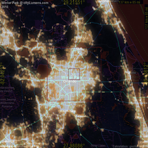
Analysis of Winter Park night lights 2016
Square area 10x10 km:
 46.59%
90-99
39.02%80-89
11.93%70-79
2.46%60-69
0%50-59
0%40-49
0%30-39
0%20-29
0%10-19
0%0-9
0%Square area 50x50 km:
21.35%90-99
20.47%80-89
8.53%70-79
10.1%60-69
8.74%50-59
2.93%40-49
3.24%30-39
4.06%20-29
5.2%10-19
5.85%0-9
9.51%Clear (daylight) street map image can be seen on geolist.org.
Map coordinates:
29° 12' 55.8" North, 82° 2' 32.5" West
28° 36' 0" North, 81° 20' 21.3" West
27° 58' 51.1" North, 80° 38' 10" West
Some cities around Winter Park sort by population:
• Orlando
7.9 km =4.9 mi,  209°
209°
• Altamonte Springs
7.3 km =4.5 mi,  339°
339°
• Maitland
3.9 km =2.4 mi,  322°
322°
• Azalea Park
7.6 km =4.7 mi,  150°
150°
• Goldenrod
5.1 km =3.2 mi,  76°
76°
• Fairview Shores
5.5 km =3.4 mi,  259°
259°
• Union Park
6.3 km =3.9 mi,  124°
124°
• Fern Park
5.6 km =3.5 mi,  347°
347°
4178560 (p: 29,943)
Sources (retrieved 2019-11-25):
» Earth at Night: Flat Maps 2012, 2016