Azalea Park night lights from space
Night Light of Azalea Park (Florida) from space (United States) Src. Average luminocity for 10x10km area is 98.2102% and for 50x50km: 66.9006%.
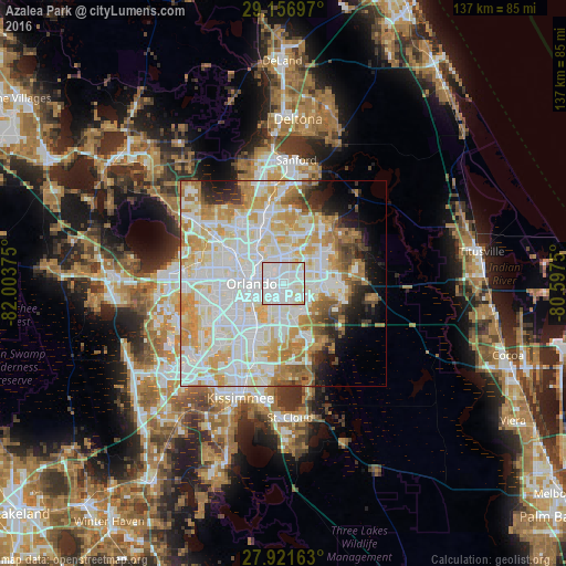
Analysis of Azalea Park night lights 2016
Square area 10x10 km:
 61.17%
90-99
32.01%80-89
6.44%70-79
0.38%60-69
0%50-59
0%40-49
0%30-39
0%20-29
0%10-19
0%0-9
0%Square area 50x50 km:
21.8%90-99
20.56%80-89
8.69%70-79
9.59%60-69
7.6%50-59
2.9%40-49
2.73%30-39
2.84%20-29
3.66%10-19
4.99%0-9
14.64%Clear (daylight) street map image can be seen on geolist.org.
Map coordinates:
29° 9' 25.1" North, 82° 0' 13.5" West
28° 32' 28" North, 81° 18' 2.2" West
27° 55' 17.9" North, 80° 35' 51" West
Some cities around Azalea Park sort by population:
• Orlando
7.7 km =4.8 mi,  267°
267°
• Alafaya
9.1 km =5.7 mi,  73°
73°
• Winter Park
7.6 km =4.7 mi,  330°
330°
• Conway
5.2 km =3.2 mi,  214°
214°
• Goldenrod
7.8 km =4.8 mi,  8°
8°
• Pine Castle
10.1 km =6.3 mi,  220°
220°
• Fairview Shores
10.7 km =6.6 mi,  301°
301°
• Union Park
3.3 km =2.1 mi,  25°
25°
4146464 (p: 12,556)
Sources (retrieved 2019-11-25):
» Earth at Night: Flat Maps 2012, 2016