Shillington night lights from space
Night Light of Shillington (Pennsylvania) from space (United States) Src. Average luminocity for 10x10km area is 70.1378% and for 50x50km: 21.6022%.
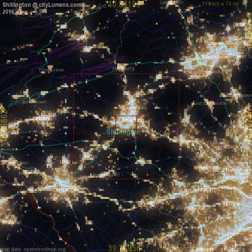
Analysis of Shillington night lights 2016
Square area 10x10 km:
 18.37%
90-99
19.73%80-89
10.88%70-79
8.5%60-69
5.95%50-59
9.52%40-49
5.44%30-39
5.61%20-29
12.93%10-19
3.06%0-9
0%Square area 50x50 km:
2.24%90-99
2.57%80-89
3.28%70-79
2.81%60-69
2.51%50-59
3.06%40-49
3.34%30-39
3.71%20-29
7.09%10-19
19.35%0-9
50.03%Clear (daylight) street map image can be seen on geolist.org.
Map coordinates:
40° 50' 30.9" North, 76° 40' 7" West
40° 18' 28.3" North, 75° 57' 55.8" West
39° 46' 10.4" North, 75° 15' 44.5" West
Some cities around Shillington sort by population:
• Reading
4.5 km =2.8 mi,  46°
46°
• Pottstown
27.7 km =17.2 mi,  104°
104°
• Ephrata
23 km =14.3 mi,  231°
231°
• Wyomissing
2.4 km =1.5 mi,  0°
0°
• Blandon
16.3 km =10.1 mi,  24°
24°
• New Holland
25.1 km =15.6 mi,  203°
203°
• Birdsboro
14.5 km =9 mi,  109°
109°
• Kutztown
28.2 km =17.5 mi,  34°
34°
5211953 (p: 5,265)
Sources (retrieved 2019-11-25):
» Earth at Night: Flat Maps 2012, 2016