Wyomissing night lights from space
Night Light of Wyomissing (Pennsylvania) from space (United States) Src. Average luminocity for 10x10km area is 81.2534% and for 50x50km: 20.73%.
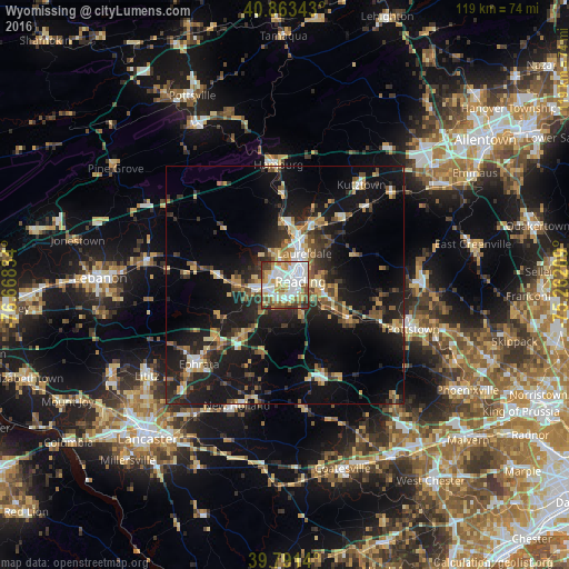
Analysis of Wyomissing night lights 2016
Square area 10x10 km:
 25%
25%90-99
25.68%80-89
11.9%70-79
10.2%60-69
5.95%50-59
9.18%40-49
6.29%30-39
4.42%20-29
1.36%10-19
0%0-9
0%Square area 50x50 km:
2.15%90-99
2.45%80-89
3.14%70-79
2.74%60-69
2.33%50-59
2.89%40-49
3.11%30-39
3.51%20-29
6.73%10-19
19.26%0-9
51.7%Clear (daylight) street map image can be seen on geolist.org.
Map coordinates:
40° 51' 48.3" North, 76° 40' 6" West
40° 19' 46.3" North, 75° 57' 54.8" West
39° 47' 29" North, 75° 15' 43.5" West
Some cities around Wyomissing sort by population:
• Reading
3.3 km =2.1 mi,  78°
78°
• Pottstown
28.4 km =17.6 mi,  109°
109°
• Ephrata
24.6 km =15.3 mi,  227°
227°
• Blandon
14.1 km =8.8 mi,  28°
28°
• New Holland
27.3 km =17 mi,  201°
201°
• Shillington
2.4 km =1.5 mi,  180°
180°
• Birdsboro
15.5 km =9.6 mi,  117°
117°
• Kutztown
26.2 km =16.3 mi,  37°
37°
5220248 (p: 10,469)
Sources (retrieved 2019-11-25):
» Earth at Night: Flat Maps 2012, 2016