Beckett Ridge night lights from space
Night Light of Beckett Ridge (Ohio) from space (United States) Src. Average luminocity for 10x10km area is 84.0136% and for 50x50km: 55.1809%.
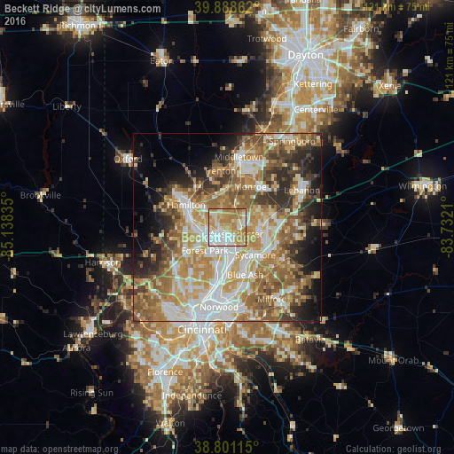
Analysis of Beckett Ridge night lights 2016
Square area 10x10 km:
 21.77%
90-99
23.81%80-89
9.35%70-79
23.47%60-69
19.9%50-59
1.7%40-49
0%30-39
0%20-29
0%10-19
0%0-9
0%Square area 50x50 km:
10.09%90-99
11.59%80-89
7.5%70-79
10.42%60-69
10.07%50-59
9.71%40-49
6.05%30-39
6.36%20-29
6.84%10-19
7.57%0-9
13.81%Clear (daylight) street map image can be seen on geolist.org.
Map coordinates:
39° 53' 19" North, 85° 8' 18.1" West
39° 20' 49.2" North, 84° 26' 6.8" West
38° 48' 4.1" North, 83° 43' 55.6" West
Some cities around Beckett Ridge sort by population:
• Hamilton
12.3 km =7.6 mi,  298°
298°
• Fairfield
10.8 km =6.7 mi,  269°
269°
• Mason
10.9 km =6.8 mi,  82°
82°
• Forest Park
8.6 km =5.3 mi,  223°
223°
• Sharonville
9 km =5.6 mi,  167°
167°
• Monroe
12.1 km =7.5 mi,  31°
31°
• Springdale
7.9 km =4.9 mi,  212°
212°
• Wyoming
13.1 km =8.1 mi,  191°
191°
4506031 (p: 9,187)
Sources (retrieved 2019-11-25):
» Earth at Night: Flat Maps 2012, 2016