Wyoming night lights from space
Night Light of Wyoming (Ohio) from space (United States) Src. Average luminocity for 10x10km area is 87.2228% and for 50x50km: 64.8457%.
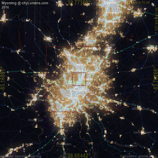
Analysis of Wyoming night lights 2016
Square area 10x10 km:
 23.98%
90-99
24.83%80-89
17.18%70-79
26.7%60-69
7.31%50-59
0%40-49
0%30-39
0%20-29
0%10-19
0%0-9
0%Square area 50x50 km:
12.93%90-99
14.48%80-89
9.3%70-79
12.85%60-69
12.55%50-59
10.63%40-49
5.45%30-39
5.23%20-29
6.66%10-19
4.43%0-9
5.49%Clear (daylight) street map image can be seen on geolist.org.
Map coordinates:
39° 46' 25.3" North, 85° 10' 8.1" West
39° 13' 52.2" North, 84° 27' 56.8" West
38° 41' 3.9" North, 83° 45' 45.6" West
Some cities around Wyoming sort by population:
• Forest Park
7.4 km =4.6 mi,  333°
333°
• Sharonville
6.1 km =3.8 mi,  47°
47°
• Finneytown
5.8 km =3.6 mi,  233°
233°
• Blue Ash
7.5 km =4.7 mi,  89°
89°
• Springdale
6.4 km =4 mi,  344°
344°
• Reading
2.2 km =1.4 mi,  112°
112°
• Mount Healthy
6.9 km =4.3 mi,  272°
272°
• Deer Park
6.8 km =4.2 mi,  115°
115°
4528793 (p: 8,411)
Sources (retrieved 2019-11-25):
» Earth at Night: Flat Maps 2012, 2016