Forest Park night lights from space
Night Light of Forest Park (Ohio) from space (United States) Src. Average luminocity for 10x10km area is 88.1786% and for 50x50km: 59.5955%.
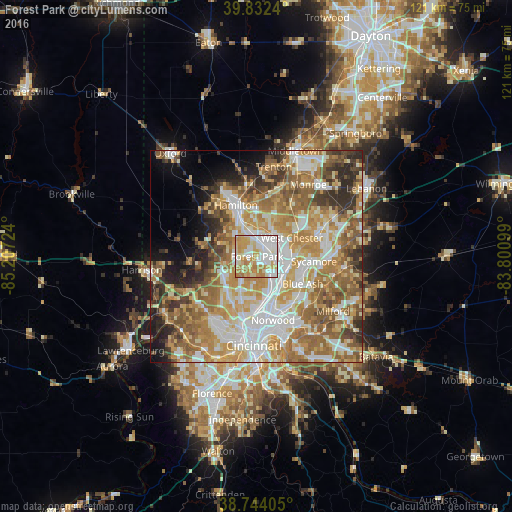
Analysis of Forest Park night lights 2016
Square area 10x10 km:
 25.51%
90-99
28.74%80-89
15.99%70-79
19.73%60-69
10.03%50-59
0%40-49
0%30-39
0%20-29
0%10-19
0%0-9
0%Square area 50x50 km:
11.63%90-99
13%80-89
8.19%70-79
11.84%60-69
11.64%50-59
10%40-49
5.09%30-39
5.85%20-29
5.57%10-19
5.17%0-9
12.02%Clear (daylight) street map image can be seen on geolist.org.
Map coordinates:
39° 49' 56.6" North, 85° 12' 26.1" West
39° 17' 25.2" North, 84° 30' 14.8" West
38° 44' 38.6" North, 83° 48' 3.6" West
Some cities around Forest Park sort by population:
• Fairfield
7.9 km =4.9 mi,  321°
321°
• Sharonville
8.2 km =5.1 mi,  107°
107°
• Springdale
1.7 km =1.1 mi,  102°
102°
• Northbrook
8.4 km =5.2 mi,  234°
234°
• Beckett Ridge
8.6 km =5.3 mi,  43°
43°
• Wyoming
7.4 km =4.6 mi,  153°
153°
• Mount Healthy
7.3 km =4.5 mi,  209°
209°
• New Burlington
5.7 km =3.5 mi, 233°
4512060 (p: 18,676)
Sources (retrieved 2019-11-25):
» Earth at Night: Flat Maps 2012, 2016