Springdale night lights from space
Night Light of Springdale (Ohio) from space (United States) Src. Average luminocity for 10x10km area is 90.7432% and for 50x50km: 61.0286%.
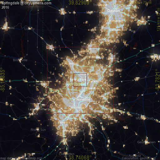
Analysis of Springdale night lights 2016
Square area 10x10 km:
 32.99%
90-99
32.48%80-89
10.88%70-79
15.31%60-69
8.33%50-59
0%40-49
0%30-39
0%20-29
0%10-19
0%0-9
0%Square area 50x50 km:
11.82%90-99
13.38%80-89
8.54%70-79
12.14%60-69
11.66%50-59
10.31%40-49
5.33%30-39
5.89%20-29
6.23%10-19
4.71%0-9
9.97%Clear (daylight) street map image can be seen on geolist.org.
Map coordinates:
39° 49' 44.7" North, 85° 11' 18.1" West
39° 17' 13.2" North, 84° 29' 6.8" West
38° 44' 26.4" North, 83° 46' 55.6" West
Some cities around Springdale sort by population:
• Fairfield
9.2 km =5.7 mi,  315°
315°
• Forest Park
1.7 km =1.1 mi,  282°
282°
• Sharonville
6.5 km =4 mi,  108°
108°
• Reading
8 km =5 mi,  152°
152°
• Beckett Ridge
7.9 km =4.9 mi,  32°
32°
• Wyoming
6.4 km =4 mi,  164°
164°
• Mount Healthy
7.9 km =4.9 mi,  221°
221°
• New Burlington
6.9 km =4.3 mi,  243°
243°
4525310 (p: 11,182)
Sources (retrieved 2019-11-25):
» Earth at Night: Flat Maps 2012, 2016