Sharonville night lights from space
Night Light of Sharonville (Ohio) from space (United States) Src. Average luminocity for 10x10km area is 93.4677% and for 50x50km: 62.0048%.
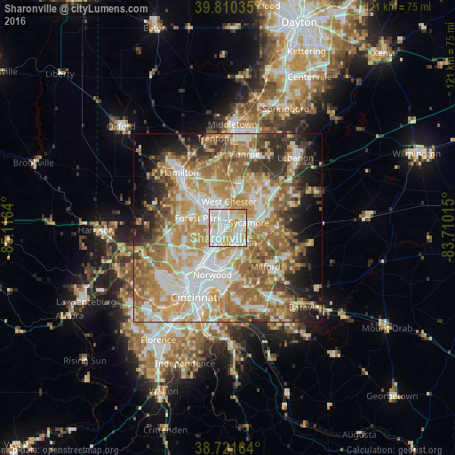
Analysis of Sharonville night lights 2016
Square area 10x10 km:
 36.56%
90-99
35.2%80-89
17.01%70-79
10.54%60-69
0.68%50-59
0%40-49
0%30-39
0%20-29
0%10-19
0%0-9
0%Square area 50x50 km:
12.02%90-99
13.59%80-89
8.97%70-79
12.19%60-69
11.87%50-59
10.17%40-49
5.35%30-39
5.34%20-29
6.06%10-19
6.95%0-9
7.49%Clear (daylight) street map image can be seen on geolist.org.
Map coordinates:
39° 48' 37.3" North, 85° 6' 59" West
39° 16' 5.2" North, 84° 24' 47.8" West
38° 43' 17.9" North, 83° 42' 36.5" West
Some cities around Sharonville sort by population:
• Forest Park
8.2 km =5.1 mi,  287°
287°
• Blue Ash
5 km =3.1 mi,  143°
143°
• Springdale
6.5 km =4 mi, 288°
• Montgomery
6.8 km =4.2 mi,  131°
131°
• Reading
5.5 km =3.4 mi,  206°
206°
• Wyoming
6.1 km =3.8 mi,  227°
227°
• Kenwood
7.5 km =4.7 mi,  148°
148°
• Deer Park
7.2 km =4.5 mi,  167°
167°
4524499 (p: 13,774)
Sources (retrieved 2019-11-25):
» Earth at Night: Flat Maps 2012, 2016