Andrews night lights from space
Night Light of Andrews (Texas) from space (United States) Src. Average luminocity for 10x10km area is 34.3736% and for 50x50km: 2.0334%.
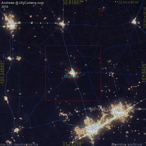
Analysis of Andrews night lights 2016
Square area 10x10 km:
 4.03%
4.03%90-99
3.85%80-89
11.17%70-79
3.85%60-69
4.03%50-59
3.48%40-49
3.85%30-39
0.55%20-29
2.75%10-19
44.14%0-9
18.32%Square area 50x50 km:
0.16%90-99
0.15%80-89
0.46%70-79
0.2%60-69
0.19%50-59
0.23%40-49
0.46%30-39
0.24%20-29
0.47%10-19
2.08%0-9
95.36%Clear (daylight) street map image can be seen on geolist.org.
Map coordinates:
32° 54' 39.5" North, 103° 14' 55.9" West
32° 19' 7.4" North, 102° 32' 44.6" West
31° 43' 21.3" North, 101° 50' 33.4" West
Some cities around Andrews sort by population:
• Midland
56.7 km =35.2 mi,  129°
129°
• Odessa
55.2 km =34.3 mi,  162°
162°
• Hobbs
69.9 km =43.4 mi,  307°
307°
• West Odessa
53.2 km =33.1 mi,  175°
175°
• Lamesa
72.6 km =45.1 mi,  50°
50°
• Monahans
86.9 km =54 mi,  202°
202°
• Seminole
45.5 km =28.3 mi,  348°
348°
• Kermit
72.7 km =45.2 mi,  225°
225°
5516288 (p: 13,816)
Sources (retrieved 2019-11-25):
» Earth at Night: Flat Maps 2012, 2016