West Odessa night lights from space
Night Light of West Odessa (Texas) from space (United States) Src. Average luminocity for 10x10km area is 50.6832% and for 50x50km: 16.1632%.
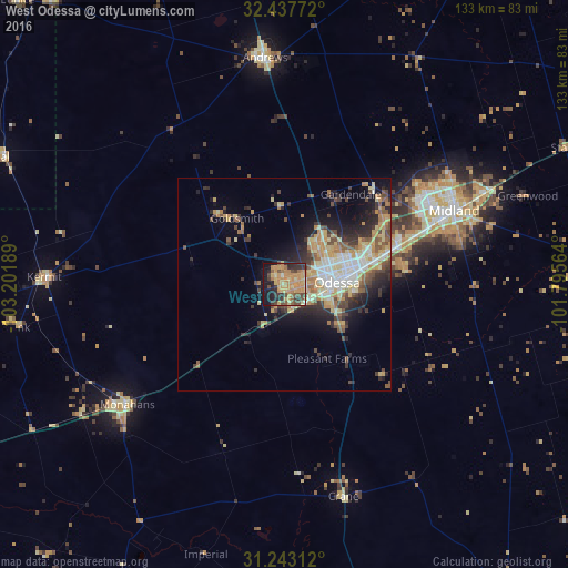

Analysis of West Odessa night lights 2016
Square area 10x10 km:
 0.73%
0.73%90-99
0.37%80-89
9.71%70-79
23.99%60-69
13.19%50-59
4.4%40-49
10.99%30-39
8.61%20-29
9.34%10-19
17.03%0-9
1.65%Square area 50x50 km:
1.78%90-99
2.11%80-89
3%70-79
3.49%60-69
2.15%50-59
2.04%40-49
2.47%30-39
2.58%20-29
4.04%10-19
6.5%0-9
69.85%Clear (daylight) street map image can be seen on geolist.org.
Map coordinates:
32° 26' 15.8" North, 103° 12' 6.8" West
31° 50' 32.5" North, 102° 29' 55.5" West
31° 14' 35.2" North, 101° 47' 44.3" West
Some cities around West Odessa sort by population:
• Midland
43.3 km =26.9 mi,  66°
66°
• Odessa
12.4 km =7.7 mi,  88°
88°
• Big Spring
106.3 km =66.1 mi,  64°
64°
• Andrews
53.2 km =33.1 mi,  355°
355°
• Pecos
105.1 km =65.3 mi,  243°
243°
• Monahans
46.4 km =28.8 mi,  233°
233°
• Seminole
98.4 km =61.1 mi,  351°
351°
• Kermit
56.1 km =34.9 mi,  271°
271°
5533366 (p: 22,707)
Sources (retrieved 2019-11-25):
» Earth at Night: Flat Maps 2012, 2016