Khrystynivka night lights from space
Night Light of Khrystynivka (Cherkasy) from space (Ukraine) Src. Average luminocity for 10x10km area is 2.2344% and for 50x50km: 1.3097%.
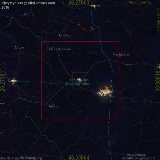
Analysis of Khrystynivka night lights 2016
Square area 10x10 km:
 0%
0%90-99
0%80-89
0.43%70-79
0.57%60-69
0.14%50-59
0%40-49
0.85%30-39
2.13%20-29
0.43%10-19
0%0-9
95.45%Square area 50x50 km:
0.11%90-99
0.13%80-89
0.09%70-79
0.19%60-69
0.18%50-59
0.11%40-49
0.36%30-39
0.27%20-29
0.49%10-19
1.03%0-9
97.05%Clear (daylight) street map image can be seen on geolist.org.
Map coordinates:
49° 16' 35.9" North, 29° 16' 26.1" East
48° 48' 56.8" North, 29° 58' 37.3" East
48° 21' 2.3" North, 30° 40' 48.6" East
Some cities around Khrystynivka sort by population:
• Uman
19.4 km =12.1 mi,  112°
112°
• Haisyn
43 km =26.7 mi,  269°
269°
• Talne
53.1 km =33 mi,  81°
81°
• Hayvoron
53.6 km =33.3 mi,  188°
188°
• Zhashkiv
48.8 km =30.3 mi,  11°
11°
• Monastyryshche
23.2 km =14.4 mi,  327°
327°
• Mankivka
30.8 km =19.1 mi,  57°
57°
• Teplyk
23.8 km =14.8 mi,  225°
225°
706200 (p: 14,056)
Sources (retrieved 2019-11-25):
» Earth at Night: Flat Maps 2012, 2016