Chervona Sloboda night lights from space
Night Light of Chervona Sloboda (Cherkasy) from space (Ukraine) Src. Average luminocity for 10x10km area is 6.861% and for 50x50km: 2.6778%.
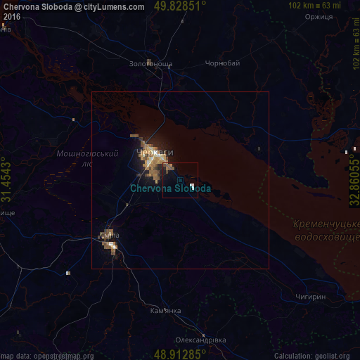
Analysis of Chervona Sloboda night lights 2016
Square area 10x10 km:
 0.8%
0.8%90-99
0.8%80-89
0%70-79
0.53%60-69
1.34%50-59
2.01%40-49
1.87%30-39
0.4%20-29
0.8%10-19
4.81%0-9
86.63%Square area 50x50 km:
0.13%90-99
0.22%80-89
0.25%70-79
0.4%60-69
0.61%50-59
0.65%40-49
0.62%30-39
0.29%20-29
0.37%10-19
2.09%0-9
94.37%Clear (daylight) street map image can be seen on geolist.org.
Map coordinates:
49° 49' 42.6" North, 31° 27' 15.5" East
49° 22' 22.1" North, 32° 9' 26.7" East
48° 54' 46.3" North, 32° 51' 38" East
Some cities around Chervona Sloboda sort by population:
• Cherkasy
9.3 km =5.8 mi,  311°
311°
• Smila
25.8 km =16 mi,  229°
229°
• Zolotonosha
33.9 km =21.1 mi,  345°
345°
• Kamianka
38.1 km =23.7 mi,  185°
185°
• Chyhyryn
48.4 km =30.1 mi,  131°
131°
• Oleksandrivka
45.9 km =28.5 mi,  172°
172°
• Chornobay
34.9 km =21.7 mi,  20°
20°
• Ruska Poliana
17.9 km =11.1 mi,  285°
285°
710587 (p: 9,333)
Sources (retrieved 2019-11-25):
» Earth at Night: Flat Maps 2012, 2016