Koani night lights from space
Night Light of Koani (Zanzibar Central/South) from space (Tanzania) Src. Average luminocity for 10x10km area is 7.9959% and for 50x50km: 3.1295%.
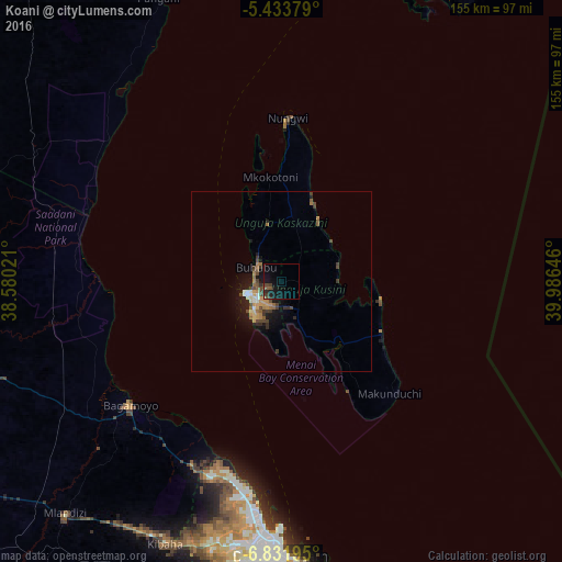
Analysis of Koani night lights 2016
Square area 10x10 km:
 0%
0%90-99
0%80-89
0%70-79
0.83%60-69
0%50-59
2.69%40-49
2.48%30-39
3.1%20-29
1.65%10-19
13.43%0-9
75.83%Square area 50x50 km:
0.11%90-99
0.3%80-89
0.23%70-79
0.66%60-69
0.44%50-59
0.59%40-49
0.83%30-39
0.74%20-29
0.45%10-19
2.86%0-9
92.78%Clear (daylight) street map image can be seen on geolist.org.
Map coordinates:
5° 26' 1.6" South, 38° 34' 48.8" East
6° 7' 60" South, 39° 16' 60" East
6° 49' 55" South, 39° 59' 11.3" East
Some cities around Koani sort by population:
• Zanzibar
10 km =6.2 mi,  250°
250°
• Bagamoyo
54.2 km =33.7 mi,  230°
230°
• Mvomero
69.4 km =43.1 mi,  259°
259°
• Sokoni
44.5 km =27.7 mi,  138°
138°
• Magomeni
74.2 km =46.1 mi,  182°
182°
• Nungwi
45.3 km =28.1 mi,  2°
2°
• Mahonda
40.6 km =25.2 mi,  150°
150°
• Mkokotoni
28.9 km =18 mi,  353°
353°
156589 (p: 2,211)
Sources (retrieved 2019-11-25):
» Earth at Night: Flat Maps 2012, 2016