Yuvacık night lights from space
Night Light of Yuvacık (Kocaeli) from space (Turkey) Src. Average luminocity for 10x10km area is 49.3052% and for 50x50km: 18.6543%.
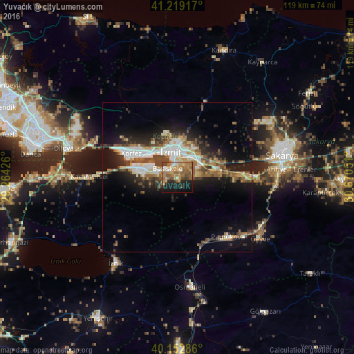
Analysis of Yuvacık night lights 2016
Square area 10x10 km:
100  2.44%
2.44%
90-99 5.84%
80-89 6.82%
70-79 11.85%
60-69 16.88%
50-59 11.04%
40-49 8.12%
30-39 1.62%
20-29 10.55%
10-19 20.62%
0-9 4.22%
2.44%90-99
5.84%80-89
6.82%70-79
11.85%60-69
16.88%50-59
11.04%40-49
8.12%30-39
1.62%20-29
10.55%10-19
20.62%0-9
4.22%Square area 50x50 km:
100 2.84%
90-99 3.38%
80-89 1.91%
70-79 2.09%
60-69 2.84%
50-59 2.97%
40-49 3.31%
30-39 2.54%
20-29 4.64%
10-19 10.52%
0-9 62.96%
2.84%90-99
3.38%80-89
1.91%70-79
2.09%60-69
2.84%50-59
2.97%40-49
3.31%30-39
2.54%20-29
4.64%10-19
10.52%0-9
62.96%Clear (daylight) street map image can be seen on geolist.org.
Map coordinates:
41° 13' 9" North, 29° 15' 51.3" East
40° 41' 17.3" North, 29° 58' 2.6" East
40° 9' 10.3" North, 30° 40' 13.8" East
Some cities around Yuvacık sort by population:
• İzmit
9.1 km =5.7 mi,  339°
339°
• Derince
15 km =9.3 mi,  300°
300°
• Körfez
17.9 km =11.1 mi, 299°
• Gölcük
8.2 km =5.1 mi,  281°
281°
• Köseköy
6.6 km =4.1 mi,  29°
29°
• İhsaniye
11.2 km =7 mi,  271°
271°
• Kullar
4.4 km =2.7 mi,  24°
24°
• Bahçecik
5 km =3.1 mi,  243°
243°
737119 (p: 7,338)
Sources (retrieved 2019-11-25):
» Earth at Night: Flat Maps 2012, 2016