Bahçecik night lights from space
Night Light of Bahçecik (Kocaeli) from space (Turkey) Src. Average luminocity for 10x10km area is 38.8198% and for 50x50km: 18.5219%.
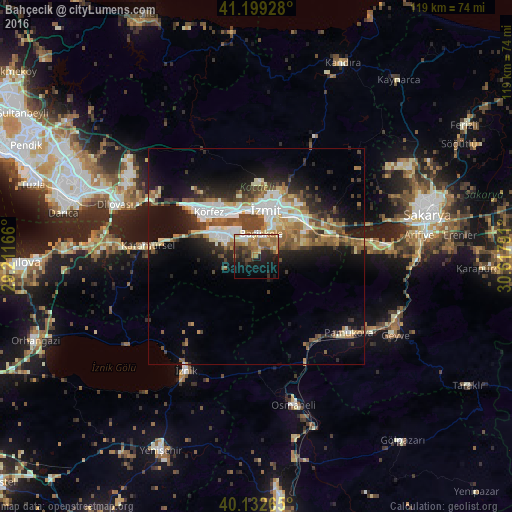
Analysis of Bahçecik night lights 2016
Square area 10x10 km:
100  3.08%
3.08%
90-99 5.03%
80-89 5.36%
70-79 7.47%
60-69 9.74%
50-59 6.17%
40-49 5.52%
30-39 6.49%
20-29 10.88%
10-19 20.13%
0-9 20.13%
3.08%90-99
5.03%80-89
5.36%70-79
7.47%60-69
9.74%50-59
6.17%40-49
5.52%30-39
6.49%20-29
10.88%10-19
20.13%0-9
20.13%Square area 50x50 km:
100 2.85%
90-99 3.38%
80-89 2.01%
70-79 2.04%
60-69 2.71%
50-59 2.99%
40-49 3.25%
30-39 2.5%
20-29 4.57%
10-19 10.37%
0-9 63.33%
2.85%90-99
3.38%80-89
2.01%70-79
2.04%60-69
2.71%50-59
2.99%40-49
3.25%30-39
2.5%20-29
4.57%10-19
10.37%0-9
63.33%Clear (daylight) street map image can be seen on geolist.org.
Map coordinates:
41° 11' 57.4" North, 29° 12' 42" East
40° 40' 5.2" North, 29° 54' 53.2" East
40° 7' 57.5" North, 30° 37' 4.5" East
Some cities around Bahçecik sort by population:
• İzmit
10.8 km =6.7 mi,  6°
6°
• Derince
13 km =8.1 mi,  319°
319°
• Körfez
15.6 km =9.7 mi,  314°
314°
• Gölcük
5.3 km =3.3 mi, 317°
• Köseköy
11.1 km =6.9 mi,  43°
43°
• İhsaniye
7.2 km =4.5 mi,  290°
290°
• Kullar
8.9 km =5.5 mi,  45°
45°
• Yuvacık
5 km =3.1 mi,  63°
63°
751277 (p: 8,648)
Sources (retrieved 2019-11-25):
» Earth at Night: Flat Maps 2012, 2016