Köseköy night lights from space
Night Light of Köseköy (Kocaeli) from space (Turkey) Src. Average luminocity for 10x10km area is 79.1867% and for 50x50km: 18.8826%.
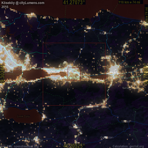
Analysis of Köseköy night lights 2016
Square area 10x10 km:
100  16.23%
90-99 21.75%
80-89 12.99%
70-79 15.91%
60-69 16.88%
50-59 11.85%
40-49 2.27%
30-39 0.81%
20-29 1.3%
10-19 0%
0-9 0%
16.23%90-99
21.75%80-89
12.99%70-79
15.91%60-69
16.88%50-59
11.85%40-49
2.27%30-39
0.81%20-29
1.3%10-19
0%0-9
0%Square area 50x50 km:
100 2.84%
90-99 3.4%
80-89 2.01%
70-79 2.15%
60-69 2.81%
50-59 3.09%
40-49 3.31%
30-39 2.64%
20-29 4.85%
10-19 11.09%
0-9 61.82%
2.84%90-99
3.4%80-89
2.01%70-79
2.15%60-69
2.81%50-59
3.09%40-49
3.31%30-39
2.64%20-29
4.85%10-19
11.09%0-9
61.82%Clear (daylight) street map image can be seen on geolist.org.
Map coordinates:
41° 16' 14.6" North, 29° 18' 8.8" East
40° 44' 24.4" North, 30° 0' 20" East
40° 12' 18.9" North, 30° 42' 31.3" East
Some cities around Köseköy sort by population:
• İzmit
7 km =4.3 mi,  293°
293°
• Derince
16.2 km =10.1 mi,  276°
276°
• Körfez
19 km =11.8 mi, 279°
• Gölcük
12 km =7.5 mi,  249°
249°
• İhsaniye
15.4 km =9.6 mi, 249°
• Kullar
2.2 km =1.4 mi,  217°
217°
• Bahçecik
11.1 km =6.9 mi, 223°
• Yuvacık
6.6 km =4.1 mi,  209°
209°
742588 (p: 9,200)
Sources (retrieved 2019-11-25):
» Earth at Night: Flat Maps 2012, 2016