Kullar night lights from space
Night Light of Kullar (Kocaeli) from space (Turkey) Src. Average luminocity for 10x10km area is 74.1899% and for 50x50km: 18.9994%.
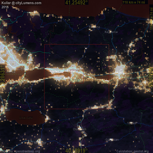
Analysis of Kullar night lights 2016
Square area 10x10 km:
 12.18%
90-99
16.72%80-89
13.31%70-79
16.07%60-69
17.69%50-59
12.34%40-49
6.33%30-39
1.79%20-29
3.57%10-19
0%0-9
0%Square area 50x50 km:
2.87%90-99
3.48%80-89
2.05%70-79
2.17%60-69
2.88%50-59
3.01%40-49
3.34%30-39
2.6%20-29
4.66%10-19
11.17%0-9
61.79%Clear (daylight) street map image can be seen on geolist.org.
Map coordinates:
41° 15' 17.7" North, 29° 17' 10.7" East
40° 43' 27.1" North, 29° 59' 21.9" East
40° 11' 21.1" North, 30° 41' 33.2" East
Some cities around Kullar sort by population:
• İzmit
6.8 km =4.2 mi,  311°
311°
• Derince
15.2 km =9.4 mi,  283°
283°
• Körfez
18.1 km =11.2 mi,  285°
285°
• Gölcük
10.2 km =6.3 mi,  256°
256°
• Köseköy
2.2 km =1.4 mi,  37°
37°
• İhsaniye
13.6 km =8.5 mi,  254°
254°
• Bahçecik
8.9 km =5.5 mi,  225°
225°
• Yuvacık
4.4 km =2.7 mi,  204°
204°
742292 (p: 8,820)
Sources (retrieved 2019-11-25):
» Earth at Night: Flat Maps 2012, 2016