Yeşilova night lights from space
Night Light of Yeşilova (Burdur) from space (Turkey) Src. Average luminocity for 10x10km area is 9.4432% and for 50x50km: 3.9891%.
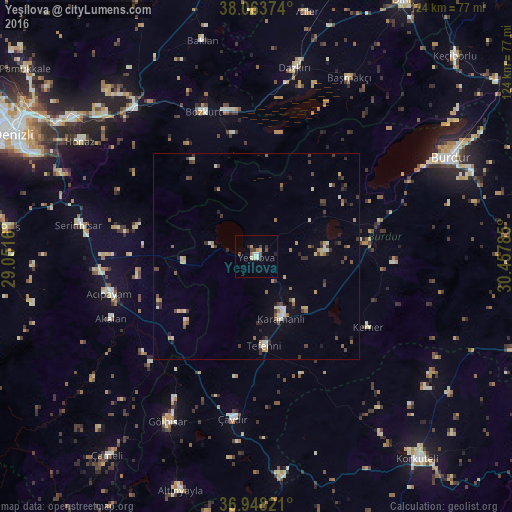
Analysis of Yeşilova night lights 2016
Square area 10x10 km:
 0.81%
0.81%90-99
1.14%80-89
1.95%70-79
1.3%60-69
0.65%50-59
0%40-49
2.92%30-39
2.11%20-29
1.14%10-19
0.32%0-9
87.66%Square area 50x50 km:
0.15%90-99
0.77%80-89
0.43%70-79
0.5%60-69
0.38%50-59
0.42%40-49
0.76%30-39
1.01%20-29
0.71%10-19
0.69%0-9
94.17%Clear (daylight) street map image can be seen on geolist.org.
Map coordinates:
38° 3' 49.5" North, 29° 3' 5.8" East
37° 30' 29" North, 29° 45' 17" East
36° 56' 53.6" North, 30° 27' 28.3" East
Some cities around Yeşilova sort by population:
• Burdur
52.8 km =32.8 mi,  63°
63°
• Serinhisar
43.8 km =27.2 mi,  280°
280°
• Gölhisar
45.8 km =28.5 mi,  208°
208°
• Acıpayam
37 km =23 mi,  255°
255°
• Başmakçı
48.8 km =30.3 mi,  27°
27°
• Honaz
50.9 km =31.6 mi,  302°
302°
• Dazkırı
46.6 km =29 mi,  11°
11°
• Tefenni
22.1 km =13.7 mi,  175°
175°
296823 (p: 6,777)
Sources (retrieved 2019-11-25):
» Earth at Night: Flat Maps 2012, 2016