Honaz night lights from space
Night Light of Honaz (Denizli) from space (Turkey) Src. Average luminocity for 10x10km area is 26.3214% and for 50x50km: 18.0183%.
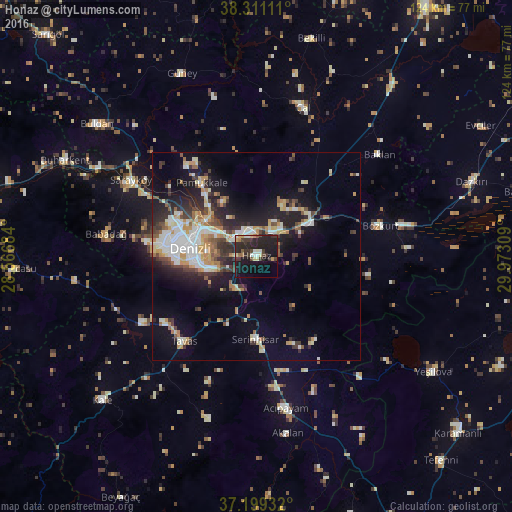
Analysis of Honaz night lights 2016
Square area 10x10 km:
 1.02%
1.02%90-99
4.59%80-89
3.23%70-79
1.36%60-69
1.53%50-59
1.87%40-49
3.4%30-39
8.84%20-29
21.77%10-19
32.48%0-9
19.9%Square area 50x50 km:
2.6%90-99
3.88%80-89
1.83%70-79
2.23%60-69
1.89%50-59
1.84%40-49
2.12%30-39
3.25%20-29
5.25%10-19
10.69%0-9
64.41%Clear (daylight) street map image can be seen on geolist.org.
Map coordinates:
38° 18' 40" North, 28° 34' 0.6" East
37° 45' 26.3" North, 29° 16' 11.9" East
37° 11' 57.6" North, 29° 58' 23.1" East
Some cities around Honaz sort by population:
• Denizli
16.1 km =10 mi,  276°
276°
• Merkezefendi
20.7 km =12.9 mi, 284°
• Sarayköy
35.5 km =22.1 mi,  301°
301°
• Serinhisar
19.6 km =12.2 mi,  180°
180°
• Tavas
26.9 km =16.7 mi,  220°
220°
• Acıpayam
37.7 km =23.4 mi,  169°
169°
• Pamukkale
22.2 km =13.8 mi,  322°
322°
• Baklan
38.5 km =23.9 mi,  50°
50°
311962 (p: 7,974)
Sources (retrieved 2019-11-25):
» Earth at Night: Flat Maps 2012, 2016