Serinhisar night lights from space
Night Light of Serinhisar (Denizli) from space (Turkey) Src. Average luminocity for 10x10km area is 14.3095% and for 50x50km: 13.0741%.
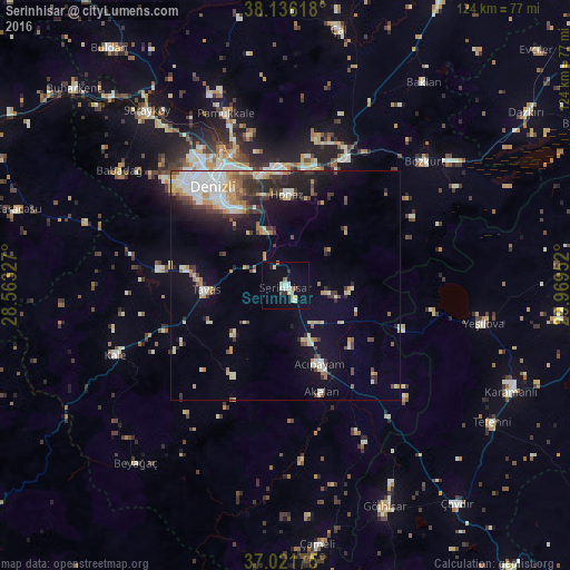
Analysis of Serinhisar night lights 2016
Square area 10x10 km:
 1.02%
1.02%90-99
3.23%80-89
3.74%70-79
0.34%60-69
1.7%50-59
0.51%40-49
0.68%30-39
1.36%20-29
1.36%10-19
2.04%0-9
84.01%Square area 50x50 km:
2.22%90-99
2.48%80-89
1.45%70-79
1.43%60-69
1.37%50-59
1.29%40-49
1.5%30-39
2.05%20-29
2.95%10-19
6.08%0-9
77.18%Clear (daylight) street map image can be seen on geolist.org.
Map coordinates:
38° 8' 10.2" North, 28° 33' 47.8" East
37° 34' 51.8" North, 29° 15' 59" East
37° 1' 18.3" North, 29° 58' 10.3" East
Some cities around Serinhisar sort by population:
• Denizli
26.6 km =16.5 mi,  323°
323°
• Merkezefendi
31.8 km =19.8 mi, 321°
• Tavas
17.3 km =10.7 mi,  267°
267°
• Acıpayam
19 km =11.8 mi,  157°
157°
• Pamukkale
39.5 km =24.5 mi,  340°
340°
• Honaz
19.6 km =12.2 mi,  0°
0°
• Kale
40.4 km =25.1 mi,  246°
246°
• Nikfer
22.6 km =14 mi,  210°
210°
307211 (p: 17,169)
Sources (retrieved 2019-11-25):
» Earth at Night: Flat Maps 2012, 2016