Gölhisar night lights from space
Night Light of Gölhisar (Burdur) from space (Turkey) Src. Average luminocity for 10x10km area is 15.4405% and for 50x50km: 5.2926%.
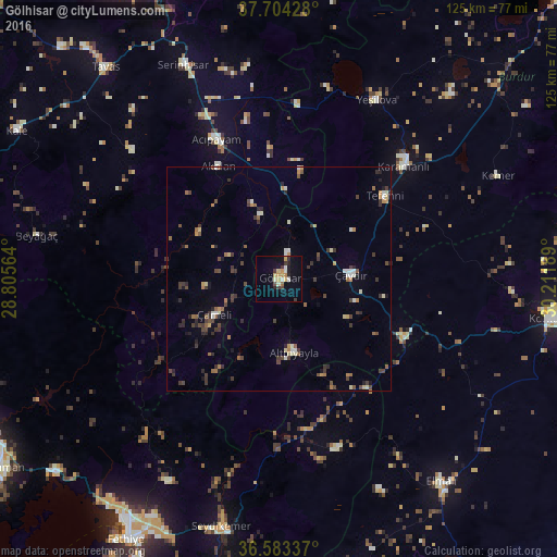
Analysis of Gölhisar night lights 2016
Square area 10x10 km:
 1.02%
1.02%90-99
2.89%80-89
1.53%70-79
3.91%60-69
1.19%50-59
0.34%40-49
1.36%30-39
3.06%20-29
2.38%10-19
7.99%0-9
74.32%Square area 50x50 km:
0.27%90-99
0.74%80-89
0.45%70-79
0.58%60-69
0.7%50-59
0.67%40-49
1.07%30-39
1.7%20-29
0.99%10-19
1.03%0-9
91.82%Clear (daylight) street map image can be seen on geolist.org.
Map coordinates:
37° 42' 15.4" North, 28° 48' 20.3" East
37° 8' 45.2" North, 29° 30' 31.5" East
36° 35' 0.1" North, 30° 12' 42.8" East
Some cities around Gölhisar sort by population:
• Korkuteli
61.6 km =38.3 mi,  98°
98°
• Serinhisar
52.9 km =32.9 mi,  336°
336°
• Elmalı
58.3 km =36.2 mi,  141°
141°
• Tavas
61.3 km =38.1 mi,  320°
320°
• Acıpayam
34 km =21.1 mi, 335°
• Yeşilova
45.8 km =28.5 mi,  28°
28°
• Nikfer
43.7 km =27.2 mi,  311°
311°
• Tefenni
29.8 km =18.5 mi,  52°
52°
314072 (p: 12,721)
Sources (retrieved 2019-11-25):
» Earth at Night: Flat Maps 2012, 2016