Tefenni night lights from space
Night Light of Tefenni (Burdur) from space (Turkey) Src. Average luminocity for 10x10km area is 8.4724% and for 50x50km: 4.8504%.
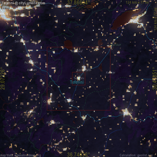
Analysis of Tefenni night lights 2016
Square area 10x10 km:
 0.65%
0.65%90-99
1.14%80-89
0.81%70-79
2.27%60-69
0.97%50-59
0%40-49
0%30-39
1.79%20-29
1.46%10-19
1.3%0-9
89.61%Square area 50x50 km:
0.28%90-99
0.99%80-89
0.53%70-79
0.68%60-69
0.44%50-59
0.56%40-49
0.61%30-39
1.15%20-29
0.67%10-19
0.96%0-9
93.14%Clear (daylight) street map image can be seen on geolist.org.
Map coordinates:
37° 52' 0.6" North, 29° 4' 20.1" East
37° 18' 34.8" North, 29° 46' 31.4" East
36° 44' 54.1" North, 30° 28' 42.6" East
Some cities around Tefenni sort by population:
• Burdur
64.4 km =40 mi,  44°
44°
• Korkuteli
46.1 km =28.6 mi,  126°
126°
• Serinhisar
54.1 km =33.6 mi,  303°
303°
• Elmalı
65 km =40.4 mi,  168°
168°
• Gölhisar
29.8 km =18.5 mi,  232°
232°
• Acıpayam
39.7 km =24.7 mi,  288°
288°
• Yeşilova
22.1 km =13.7 mi,  355°
355°
• Nikfer
57.4 km =35.7 mi,  280°
280°
299499 (p: 5,317)
Sources (retrieved 2019-11-25):
» Earth at Night: Flat Maps 2012, 2016