Acıpayam night lights from space
Night Light of Acıpayam (Denizli) from space (Turkey) Src. Average luminocity for 10x10km area is 17.8117% and for 50x50km: 5.4126%.
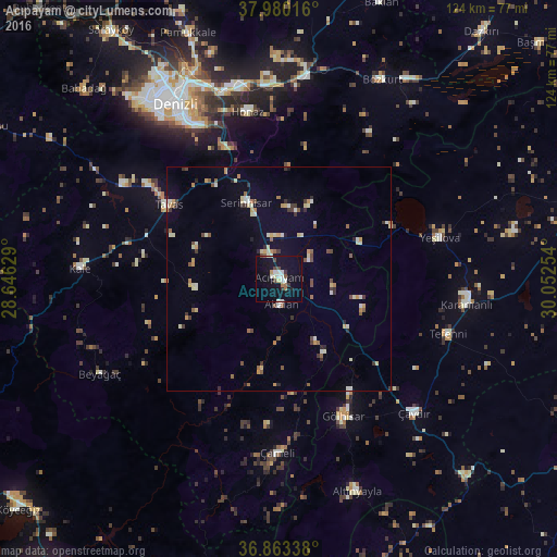
Analysis of Acıpayam night lights 2016
Square area 10x10 km:
 1.95%
1.95%90-99
4.55%80-89
1.3%70-79
0.65%60-69
1.79%50-59
0.81%40-49
3.08%30-39
2.11%20-29
0.32%10-19
24.35%0-9
59.09%Square area 50x50 km:
0.27%90-99
1.1%80-89
0.69%70-79
0.63%60-69
0.54%50-59
0.72%40-49
0.68%30-39
0.77%20-29
0.54%10-19
1.68%0-9
92.37%Clear (daylight) street map image can be seen on geolist.org.
Map coordinates:
37° 58' 48.6" North, 28° 38' 46.6" East
37° 25' 25.9" North, 29° 20' 57.9" East
36° 51' 48.2" North, 30° 3' 9.1" East
Some cities around Acıpayam sort by population:
• Serinhisar
19 km =11.8 mi,  337°
337°
• Gölhisar
34 km =21.1 mi,  155°
155°
• Tavas
29.7 km =18.5 mi,  304°
304°
• Honaz
37.7 km =23.4 mi,  349°
349°
• Kale
44.5 km =27.7 mi,  272°
272°
• Yeşilova
37 km =23 mi,  75°
75°
• Nikfer
18.8 km =11.7 mi,  263°
263°
• Tefenni
39.7 km =24.7 mi,  108°
108°
325426 (p: 10,924)
Sources (retrieved 2019-11-25):
» Earth at Night: Flat Maps 2012, 2016