Yalıhüyük night lights from space
Night Light of Yalıhüyük (Konya) from space (Turkey) Src. Average luminocity for 10x10km area is 3.5909% and for 50x50km: 3.8007%.
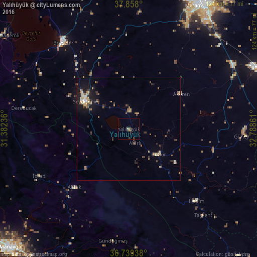
Analysis of Yalıhüyük night lights 2016
Square area 10x10 km:
 0%
0%90-99
0%80-89
0.65%70-79
0%60-69
0%50-59
1.62%40-49
0.97%30-39
2.44%20-29
0.16%10-19
0%0-9
94.16%Square area 50x50 km:
0.18%90-99
0.52%80-89
0.48%70-79
0.54%60-69
0.44%50-59
0.57%40-49
0.72%30-39
0.95%20-29
0.74%10-19
2.26%0-9
92.59%Clear (daylight) street map image can be seen on geolist.org.
Map coordinates:
37° 51' 28.8" North, 31° 22' 56.5" East
37° 18' 2.8" North, 32° 5' 7.7" East
36° 44' 21.8" North, 32° 47' 19" East
Some cities around Yalıhüyük sort by population:
• Seydişehir
25 km =15.5 mi,  301°
301°
• Beyşehir
52.6 km =32.7 mi,  322°
322°
• Hadim
47.9 km =29.8 mi,  136°
136°
• Akseki
38.4 km =23.9 mi,  223°
223°
• Bozkır
18.9 km =11.7 mi,  130°
130°
• İbradı
48.7 km =30.3 mi,  242°
242°
• Eksere
54.7 km =34 mi,  187°
187°
• Derebucak
51.9 km =32.2 mi,  281°
281°
297839 (p: 6,116)
Sources (retrieved 2019-11-25):
» Earth at Night: Flat Maps 2012, 2016