İbradı night lights from space
Night Light of İbradı (Antalya) from space (Turkey) Src. Average luminocity for 10x10km area is 3.4065% and for 50x50km: 1.4919%.
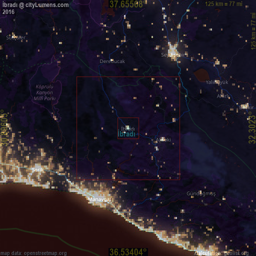
Analysis of İbradı night lights 2016
Square area 10x10 km:
 0.17%
0.17%90-99
1.19%80-89
0.68%70-79
0%60-69
0%50-59
0.68%40-49
0.68%30-39
0.34%20-29
1.02%10-19
0.17%0-9
95.07%Square area 50x50 km:
0.01%90-99
0.19%80-89
0.12%70-79
0.14%60-69
0.2%50-59
0.14%40-49
0.58%30-39
0.45%20-29
0.43%10-19
0.63%0-9
97.11%Clear (daylight) street map image can be seen on geolist.org.
Map coordinates:
37° 39' 20.4" North, 30° 53' 45.8" East
37° 5' 49" North, 31° 35' 57" East
36° 32' 2.5" North, 32° 18' 8.3" East
Some cities around İbradı sort by population:
• Manavgat
37.2 km =23.1 mi,  201°
201°
• Seydişehir
41.9 km =26 mi,  31°
31°
• Serik
48.7 km =30.3 mi,  245°
245°
• Akseki
17.8 km =11.1 mi,  107°
107°
• Side
41.2 km =25.6 mi,  206°
206°
• Yalıhüyük
48.7 km =30.3 mi,  62°
62°
• Eksere
47.5 km =29.5 mi,  131°
131°
• Derebucak
33.7 km =20.9 mi,  346°
346°
322817 (p: 8,883)
Sources (retrieved 2019-11-25):
» Earth at Night: Flat Maps 2012, 2016